Avalook at Australia News
Issue Number 35, 22 September 2002
ISSN 1443-0797
Editors: Eric Lindsay and Jean Weber
info@avalook.com.au
In this issue...
Our northern Australia trip 2002, Part 4: Kakadu and Nitmiluk
For more information about places mentioned
Fuel prices
Lonely Planet books on cycling in Australia and Aboriginal
Australia
Daylight savings times in Australia
Subscription information
Our northern Australia trip 2002, Part 4: Kakadu and Nitmiluk
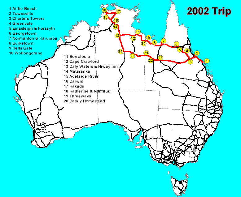
A map of the trip route is here: http://www.avalook.com.au/trips02/nq-nt-tripmap.gif
In our previous episode, we drove from Borroloola to Darwin in the Northern Territory. In this episode, we visit Kakadu and Nitmiluk National Parks.
Tuesday 30 July 2002.
We headed out of Darwin towards Adelaide, turning off after 20 km onto the
Arnhem Highway towards Kakadu National Park.
This (northern) approach to Kakadu has some boring stretches as well as the occasional point of interest. There are a set of apparently competing "jumping crocodile" river cruises, one of which claims to be the original. At the Mary River National Park you can hire boats. Termite mounds of formidable size line the roads in many areas.
We collected lunch from the Bark Hut roadhouse at Annaburoo (12-54.014S 131-40.563E). The Kakadu entry gate wasn't much further along (12-48.054 132-07.711E). We ate lunch at some facilities just past that. The flies were bad, and biting insects were to be a feature of Kakadu. (Every tour's list of "things to bring" started with insect repellent.)
We stopped for the day at Aurora Kakadu Resort near the South Alligator River (12-40.465S 132-28.991E), where there was a large group of cabins catering for bus tours and travellers. There was also a slightly neglected but adequate camping and caravan area. They had plenty of space, but the showers were again designed by people who don't use showers.
We walked to the Anggardabal billabong in the late afternoon, and saw a reasonable selection of water birds. The water level was down a considerable amount. The mosquito population was aggressive, active and slow.
The open face steak sandwich dinner we had that night was of staggering size and quite tasty.
Wednesday 31 July 2002.
We stopped a kilometre up the road at the South Alligator River and observed
birds. The easiest to see were the flocks of cockatoos, which had a white
fluffy crest, unlike the sulphur crested ones we usually see. We think these
are type called "Little Corella" but we're not birders, so we could be wrong.
We saw a number of nests in the trees, but the nests were probably those of
predator birds like kites.
 We
continued another 11 km to the Mamukala billabong, which had a splendid large
(partially enclosed) observing platform, a wonderfully cool, breezy, well
shaded spot. Numerous species of water fowls could be seen around this much
larger waterhole. We also saw a few colourful species of smaller birds, one
looking like a miniature kingfisher.
We
continued another 11 km to the Mamukala billabong, which had a splendid large
(partially enclosed) observing platform, a wonderfully cool, breezy, well
shaded spot. Numerous species of water fowls could be seen around this much
larger waterhole. We also saw a few colourful species of smaller birds, one
looking like a miniature kingfisher.
We booked into the Aurora caravan park at Jabiru, just near the Kakadu Highway turnoff (12-39.799S 132-50.152E). After leaving a table and chairs to mark our camp site, we departed again for the 40 km drive to Ubirr in the East Alligator area. This is quite a good paved road, in contrast to the gravel track that Jean and her parents didn't take in 1990. The only real problem was that we did our entire walk in the blaze of the mid-afternoon tropical sun, and that was noticeable. We were amused at the signs: "Carry lots of water--and drink it!"

 Ubirr
has an extensive collection of aboriginal rock art, all of which you can view
during an easy walk. Some of the art was related to food, as you would expect.
One place has been compared to a restaurant menu: a whole series of detailed
drawings of edible fish, in a row on an outcropping over a shallow cave that
would have done nicely as a place to prepare and eat food.
Ubirr
has an extensive collection of aboriginal rock art, all of which you can view
during an easy walk. Some of the art was related to food, as you would expect.
One place has been compared to a restaurant menu: a whole series of detailed
drawings of edible fish, in a row on an outcropping over a shallow cave that
would have done nicely as a place to prepare and eat food.
A lot of the artwork had been repainted, or painted over, during the time the site was used. Many paintings were done almost as X-rays, with the interior skeleton of the fish or whatever visible, as well as their shape, although this is said to be a recent method.
There was a Rainbow Serpent, of course. At one point we saw a painting underneath a tall overhang. We could only suspect there was once a tree there (the legend is that the spirits could lift the rock and put it back). One painting appears to show a Tasmanian Tiger, now extinct. Other paintings show European contact: figures with hands in their pockets, wearing shoes, and smoking a pipe.
 We walked to the top of a lookout, where we had marvellous views of the Narbab
floodplains and lakes, as well as some of the other rock formations. The walk
up was relatively easy, although very steep in parts and quite poorly marked.
Getting down again was be a bit more exciting; Jean ended up sitting down
and sliding off the rocks in a few places, since her knees don't take well
to climbing down. However the view was well worth the effort.
We walked to the top of a lookout, where we had marvellous views of the Narbab
floodplains and lakes, as well as some of the other rock formations. The walk
up was relatively easy, although very steep in parts and quite poorly marked.
Getting down again was be a bit more exciting; Jean ended up sitting down
and sliding off the rocks in a few places, since her knees don't take well
to climbing down. However the view was well worth the effort.
 We
had lunch in the motorhome, and thus mostly escaped the flies. We couldn't
manage another walk, although there are others in the Border Store and Manbiyarra
areas nearby. The river cruise is also reputed to tell you much of aboriginal
culture.
We
had lunch in the motorhome, and thus mostly escaped the flies. We couldn't
manage another walk, although there are others in the Border Store and Manbiyarra
areas nearby. The river cruise is also reputed to tell you much of aboriginal
culture.
Upon getting back to Jabiru, we parked in the township, where we found the postal agency, a newsagency, and a Woolworths supermarket. The town was designed for over 3000 people, but the Ranger mine has never had more than 1200 people. The town includes features like a tunnel under the main road to the high school. We drove past the expensive hotel, built to resemble a crocodile (it's particularly noticeable from the air), but didn't go in.
We had a large, delicious barramundi meal at the campground's bar/bistro area by the large swimming pool, which is mostly covered by shadecloth, a necessity in this climate.
Thursday 1 August 2002.
After a morning doing laundry and other chores, we drove to the airport for
our tours.
 The
Ranger open cut uranium mine was interesting, especially if you like hearing
about industrial processing. The overburden is removed by a combination of
blasting and digging, and stockpiled by the radiation levels. The ore is crushed
down progressively smaller, before being turned into a fine powder. They extract
uranium as the oxide (U3O8), not as yellowcake. The giant piles of yellow
stuff are sulphur, used to make sulphuric acid for the extraction process.
The
Ranger open cut uranium mine was interesting, especially if you like hearing
about industrial processing. The overburden is removed by a combination of
blasting and digging, and stockpiled by the radiation levels. The ore is crushed
down progressively smaller, before being turned into a fine powder. They extract
uranium as the oxide (U3O8), not as yellowcake. The giant piles of yellow
stuff are sulphur, used to make sulphuric acid for the extraction process.
They monitor the radiation levels of the water used, and go through a lot of water for settling dust. The grounds are covered with lawn, with watering systems working most of the time, as this helps settle dust. Naturally there is water life in the ponds. At the end of the life of the mine, the company has to restore the surface. This has already been done in one area that formerly contained a construction town, and it is hard to tell it from virgin scrub after nearly 20 years.
 We
took a late afternoon one hour flight in a small plane over the East Alligator
River and Ubirr. The flight gave a marvellous opportunity to see part of Kakadu
from above. No way you could get to many of these areas by vehicle.
We
took a late afternoon one hour flight in a small plane over the East Alligator
River and Ubirr. The flight gave a marvellous opportunity to see part of Kakadu
from above. No way you could get to many of these areas by vehicle.
Back at the caravan park, Eric visited some people with a fine example of a WORT (Weird Off Road Truck), however they hadn't heard of Rob Gray's website, http://www.robgray.com/motorhomes/rigs/index.htm. Eric spent an entertaining hour or so talking with the owners. They were going along with the people from the travelling show (in Darwin last week when we were there, and due next in Mt Isa).
Friday was a rest day.
Saturday 3 August 2002.
 We
packed up and drove to Cooinda, where we set up camp again. Jean and her parents
stayed in one of the (expensive) rooms on their 1990 trip. Park literature
suggests that the rooms (both here and at Jabiru are often booked out, but
the campgrounds rarely are full. Certainly when we were there, we saw plenty
of empty campsites, at least in the unpowered areas.
We
packed up and drove to Cooinda, where we set up camp again. Jean and her parents
stayed in one of the (expensive) rooms on their 1990 trip. Park literature
suggests that the rooms (both here and at Jabiru are often booked out, but
the campgrounds rarely are full. Certainly when we were there, we saw plenty
of empty campsites, at least in the unpowered areas.
On our way, we stopped at the Bowali Information Centre. This includes an aboriginal cultural centre, which had some interesting information about the local clan groups. We spent about an hour there, and could easily have stayed longer. It was very well laid out and explained things clearly.

 We
also took a side trip to Nourlangie Rock, another easily accessible site for
rock art. Here there was a 1 km walking track, with four or so rock art areas
you could view. We thought Ubirr was better, but these were also interesting.
There was also a viewing area for some reasonably dramatic cliff sides. Everything
was well signposted, and had easy access to most of it. The crowds (helped
by the arrival of several tour buses) were definitely much larger than at
Ubirr.
We
also took a side trip to Nourlangie Rock, another easily accessible site for
rock art. Here there was a 1 km walking track, with four or so rock art areas
you could view. We thought Ubirr was better, but these were also interesting.
There was also a viewing area for some reasonably dramatic cliff sides. Everything
was well signposted, and had easy access to most of it. The crowds (helped
by the arrival of several tour buses) were definitely much larger than at
Ubirr.
We passed on visiting some of the other sites, partly because of the heat, but mostly because Jean's knees wouldn't take the climbing. Fortunately, Jean had seen some of these sites when she was here before.
At Cooinda (88065 km 12-54.320S 132-31.205E), we ate dinner at the bistro. Eric had a snack, and Jean sampled the salad bar. It didn't have a large range of items, but what it did have were good. Most other people appeared to be buying a barbecue-it-yourself steak along with salad or hot vegetables.

 Sunday
4 August 2002.
Sunday
4 August 2002.
Up early to catch the shuttle bus to Yellow Water for the two hour dawn cruise,
a marvelous experience. Spectacular sunrise over the billabong and Alligator
Creek water, with mysterious mists above the water, through which crocodiles
swam silently. We saw a wide variety of water birds, all well described by
the guide. This is one of the better river trips we've taken, especially for
bird watchers. It was so early that it was even chilly on the water.
After a late breakfast we walked the kilometre to the Warradjan Aboriginal Cultural Centre, which like others had some brief but interesting information about the local clan groups. Some of the printed fabric and other items for sale in the shop were attractive, and mostly of much better quality than is available in many tourist stores. We have no place to put souvenirs and Jean isn't sewing much anymore, so we didn't buy anything.
Monday 5 August 2002.
We left Cooinda in the morning. We stopped briefly at the Mardagal camping
ground and went for a walk to the billabong. Very peaceful, but not nearly
the bird life of others.
We continued west on the Kakadu Highway, another road that hadn't been paved in 1990. Then, if you had a non-4WD rental car, as we did, you had to turn back from Cooinda and retrace your path almost to Darwin.
 We
stopped briefly at Mary River Roadhouse for a snack, then continued on to
Pine Creek, where we ate lunch. Turning south on the Stuart Highway, after
50 km we diverted to Leliyn (Edith Falls) in the Nitmiluk National Park. There
we were delighted to discover a pleasant campground with plenty of space available,
so we booked in.
We
stopped briefly at Mary River Roadhouse for a snack, then continued on to
Pine Creek, where we ate lunch. Turning south on the Stuart Highway, after
50 km we diverted to Leliyn (Edith Falls) in the Nitmiluk National Park. There
we were delighted to discover a pleasant campground with plenty of space available,
so we booked in.
The cold water in the large natural pool by the falls was a welcome shock after the heat of the day. We didn't feel up to swimming the entire distance across the pool to the falls, though Eric could have done so if the water had been warmer. The bushwalks were all too long and hard to contemplate.
Much refreshed, we ate dinner, purchased earlier from the kiosk, which stops serving food in the mid-afternoon.
 Tuesday
6 August 2002.
Tuesday
6 August 2002.
Leaving Edith Falls, we drove into Katherine and immediately headed east to
Nitmiluk Gorge (formerly known as Katherine Gorge, 14-19.063S 132-25.229E),
arriving in plenty of time to get a powered campsite for two nights. By mid-afternoon,
this popular spot had completely filled, although there were still some unpowered
sites vacant.
We were surprised to discover that Jean's CDMA phone was getting a strong signal here, and later chats with staff revealed that the service had only become operational a few days earlier.
As we parked, someone came up to tell us that our rear fuel tank appeared to be bouncing a lot on its supports. Closer inspection revealed that one of the three steel supports was completely broken, and another was splitting. Alarmed, we siphoned the remaining 70 litres of fuel from that tank into the front tank and Jean phoned around to locate a truck repairer in Katherine and make arrangements to have the supports rewelded.
 Dinner
was at the bistro in the Information Centre. Good food, but expensive.
Dinner
was at the bistro in the Information Centre. Good food, but expensive.
Wednesday 7 August 2002.
We had a choice of 2-hour, 4-hour, or 8-hour cruises on the Gorge, and chose
the 4-hour cruise. In retrospect, we don't think it was worth the extra time
and money, as the extra time was mostly taken up with opportunities to swim,
which didn't interest us all that much, and the most interesting (to us) part
of the trip was on the same stretch of river covered by the 2-hour cruise.
 The
gorge itself is quite spectacular, and hordes of people in canoes were paddling
leisurely along. At two places we had to get out of the boats and climb over
rocks to the next pool, where another boat awaited us. The paddlers had to
carry their canoes with them, usually over or alongside some minor rapids.
Amazing flood heights, 18 metres. Spectacular cliffs.
The
gorge itself is quite spectacular, and hordes of people in canoes were paddling
leisurely along. At two places we had to get out of the boats and climb over
rocks to the next pool, where another boat awaited us. The paddlers had to
carry their canoes with them, usually over or alongside some minor rapids.
Amazing flood heights, 18 metres. Spectacular cliffs.
After the cruise we departed our campsite and drove very slowly and carefully (so as not to bounce the rear tank too much) back to Katherine, where we located the repair place, RJ Motors, 3 km north of town on the main highway. They were able to remove the tank and its brackets that day, so we could drive away and find a place to camp for the night (rather than going to a motel as we'd done in Darwin).
Next episode: Katherine and beyond.
For more information about places mentioned
Kakadu National Park http://www.ea.gov.au/parks/kakadu/
Mary River National Park http://www.nt.gov.au/ipe/paw/parks/mary.htm
Nitmiluk National Park http://www.nt.gov.au/ipe/paw/parks/nitmiluk.htm
Fuel prices
Try this site to get a good idea of fuel prices around the country. This link is to the Northern Territory prices. http://www.shell.com.au/petrolpricing/index_nt.html
Lonely Planet books on cycling in Australia and Aboriginal Australia
Cycling Australia> by Nicola Wells and others, July 2001
Aboriginal Australia and the Torres Strait Islands by Sarina Singh and others, July 2001
Daylight savings times in Australia
Daylight savings time start and stop dates, plus a handy chart comparing times in different states http://www.dstc.qut.edu.au/DST/marg/daylight.html.
© Copyright 2002 Eric Lindsay and Jean Weber. All rights reserved.
This newsletter is available as e-mailed ASCII text.
You may forward this newsletter (in whole or in part) to friends and colleagues, as long as you retain this copyright and subscription information, and do not charge any fee.
Subscription information
This newsletter is not sent unsolicited. All the e-mail addresses in our database have been submitted to us for inclusion.
To subscribe, use signup box at left.
To unsubscribe, follow instructions at the end of each newsletter you receive.
The subscribe and unsubscribe addresses are handled automatically by a computer, and are not seen by humans.
To contact a human, send e-mail to: info@avalook.com.au
Privacy Statement
We do not sell, rent or give our mailing list to anyone.
Home | Newsletter | Places | The Shop | Transport | Topics | About us | Index | Search
Brought to you by:
Eric Lindsay and Jean Weber
P.O. Box 640, Airlie Beach, Qld 4802, Australia
Contact us info@avalook.com.au
ABN 96 350 124 090
Page last updated 20 October 2002
http://www.avalook.com.au/newsletr/oznews35.htm
![]()
![]()