The Kimberley
Northern Western Australia
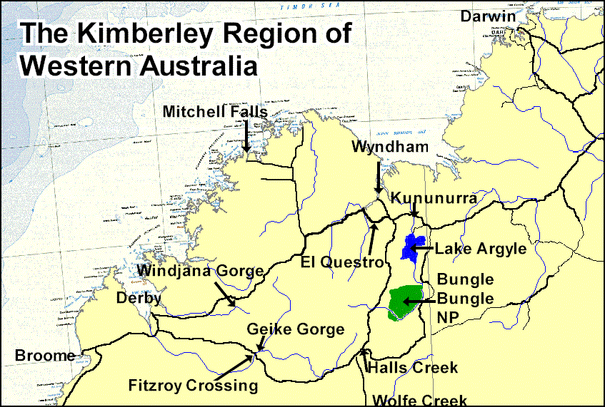
The Kimberley region is located in the northern part of Western Australia, extending from Broome in the west to Kununurra and Lake Argyle in the east, from the sea to a bit south of the main Great Northern Highway (Route 1). It covers about 421,000 square kilometres -- slightly larger than Japan and much larger than United Kingdom, New Zealand, or the Australian state of Victoria. It is bordered on the west by the Indian Ocean, on the north by the Timor Sea, on the south by the Great Sandy Desert, and on the east by the Northern Territory. Click on the map to see it larger.
 The
Kimberley has only three towns with a population of more than 2,000 (Broome,
Derby and Kununurra), and the total population is only around 25,000. In addition
to Route 1 (a sealed road), which runs along the southern part of the area,
the unsealed Gibb River Road runs through the heart of the region from Derby
to the highway near Kununurra. Access to much of the region is by dirt road
(often impassable in the wet season), air (a helicopter is necessary for many
parts) or sea.
The
Kimberley has only three towns with a population of more than 2,000 (Broome,
Derby and Kununurra), and the total population is only around 25,000. In addition
to Route 1 (a sealed road), which runs along the southern part of the area,
the unsealed Gibb River Road runs through the heart of the region from Derby
to the highway near Kununurra. Access to much of the region is by dirt road
(often impassable in the wet season), air (a helicopter is necessary for many
parts) or sea.
The Kimberley region was one of the earliest settled parts of Australia, with numerous groups of people arriving over thousands of years from the islands of what is now Indonesia. European settlement, however, is quite recent, dating from around 1885, when the MacDonalds and the Duracks arrived to set up cattle stations, having spent several years droving their cattle from the eastern colonies. Many other Europeans arrived soon after, when gold was discovered around Halls Creek. Although the gold rush didn't last long, some people stayed.
Other industries have included pearling (a big industry in Broome for many years until the 1940s), mining (including the Argyle Diamond mine, which began operation in 1983 and is still producing about 1/3 of the world's diamonds), agriculture (centred on the Ord River Irrigation Area near Lake Argyle) and tourism. The geology of the area is varied and fascinating, as well as producing some spectacular scenery. You can also see some ancient Aboriginal rock art.
This page includes information and links about:
- Transportation
- Coastal cruises
- Places to see
- Accommodation
- Communication
- Books and maps about the area
- Other internet sources of information
Transportation
Getting there
You have several choices:
- Take a tour from Darwin, Perth, or elsewhere and let them arrange all the transportation
- Fly or take a bus to Broome, Derby or Kununurra and take a tour or rent a vehicle there
- Take the bus and get off in one of the small towns along the way
- Drive your own or a rental vehicle -- but be warned that some rental companies may restrict where you can go, especially in a standard (non-4-wheel-drive) vehicle.
Seeing the area
Numerous companies run tours through the Kimberley, by land, sea or air. Land tours are available from Broome, Derby, Wyndham, Kununurra and Fitzroy Crossing, or as one-way trips between Broome and Darwin. Some tours don't stray far off the main road, while others (4-wheel-drive) venture into the more rugged areas. Either way, there's plenty to see and do. Sea or air tours are more expensive, but can take you to places impossible to reach by land.
You can rent a car or camper or drive your own. If you plan to travel on your own, you'll need to have a suitable vehicle (4 wheel drive in some cases), emergency supplies, and a good book (or several) to give you lots more relevant information than you'll find on this web site or any other site I've seen. You can also join one of the "tag-along" tours. You then have the advantage of a support vehicle and people to help out if you get into trouble. If you're not experienced with 4WD travel, but don't want to be cooped up in a bus with a group of strangers, a tag-along trip is an excellent compromise.
For the really adventurous, you can even ride a bicycle or walk, and probably someone runs motorcycle tours.
During the wet season (November through April), unsealed roads are often impassable, even for 4-wheel-drive vehicles, and sealed roads may be cut off by flood waters for a few hours to a few days. Many attractions and national parks are closed during the wet season.
And remember, it may be a long way between service stations, so make sure you refuel whenever you can, check ahead to make sure fuel is available where you're going, and perhaps even carry extra fuel. The usual outback precautions on water, spare parts for your vehicle, and so on also apply.
Check our page for campervan rentals. Several of the major companies have 4WD campervans for rent. For details about tour companies and other 4WD vehicle rental companies, check some of the website links below.
Road condition reports
In any season, before setting out on your journey, you are well advised to check on road conditions with the police, the state main roads department, or local branches of the automobile club. Here are some web sites to help you:
- Western Australian road conditions
- http://www.mrwa.wa.gov.au/ -- click on the "Touring WA" link; on the next page you'll find a link for traffic and road conditions, and links to info on roadside amenities and rest areas. Amenities and rest areas list shows toilets, shade, water, fireplaces, telephones, but not fuel.
- Northern Territory road conditions
- http://www.nt.gov.au/dtw/links/roadreport.shtml (needs Java)
- RAC (Royal Automobile Club of Western Australia)
- http://www.rac.com.au
Cruises
Other ways to see the Kimberley is by air or by sea. Here are some cruises along the Kimberley coast:
Coral Princess Cruises http://www.coralprincess.com.au have an 11-day "Across the top of Australia" cruise from Thursday to Darwin, and a 10-day Kimberley cruise.
Kimberley Quest offers 4-14 day Kimberley cruises. Contact reservations@kimberleyquest.com.au.
Red Sky Cruises offer exclusive cruises along the Kimberley coast.
Places to see
We won't attempt to duplicate all the information found on other sites, but here are some place names and what's most interesting about them.
- Bell Gorge
- In the King Leopold Range National Park.
- Broome
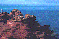 On
the west coast, the region's largest town. Famous for pearling industry,
Aboriginal rock music and theatre, and beautiful scenery including Cable
Beach, Town Beach and Mangrove Point. Sometimes called "the Byron Bay of
the West".
On
the west coast, the region's largest town. Famous for pearling industry,
Aboriginal rock music and theatre, and beautiful scenery including Cable
Beach, Town Beach and Mangrove Point. Sometimes called "the Byron Bay of
the West". - Bungle Bungle (Purnululu) National Park
- A collection of surreal beehive-shaped domes; Cathedral Gorge is a highlight.
- China Wall
- An interesting quartz outcropping near Halls Creek.
- Derby
 An
administration centre with facilities such as banking, shopping and auto
repair.
An
administration centre with facilities such as banking, shopping and auto
repair. - El Questro
- A cattle station, resort and wilderness park, from which you can take bushwalks or a cruise into Chamberlain Gorge, which features Aboriginal rock art.
- Fitzroy Crossing
- On Route 1. The turnoff to Geiki Gorge.
- Geike Gorge
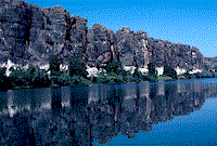 A
cruise through this pictureque gorge, formed by the Fitzroy River, shows
ancient coral reef (part of the same reef as at Windjana Gorge).
A
cruise through this pictureque gorge, formed by the Fitzroy River, shows
ancient coral reef (part of the same reef as at Windjana Gorge). - Halls Creek
- The site of Western Australia's first gold rush in 1885; you can still pan for gold at Old Halls Creek.
- Kununurra
- A modern business centre associated with the Ord River irrigation area and the Argyle diamond mine.
- Lake Argyle
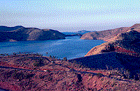 Formed
by a dam on the Ord River.
Formed
by a dam on the Ord River.- Mitchell Falls
- Located 240 km of often rough 4-wheel-drive road from the Gibb River Road, this area (on the northern coast) has spectacular scenery, bushwalking and camping facilities.
- Windjana Gorge
- The walls expose an ancient coral reef. You can walk through the gorge.
- Wolfe Creek Meteorite Crater
- Located 114 km south of the Great Northern Highway; turnoff is near Halls Creek.
- Wyndham
- The Kimberley's original port, but not very active now. The town has some interesting historical buildings and a great lookout.
Accommodation
In addition to the towns (which have hotels, motels, backpacker hostels and campgrounds), and the El Questro resort, many stations along the Gibb River Road provide camping and homestead accommodation. Check on Home Valley, Durack River, Ellenbrae, Mt Elizabeth, Mount House and Mt Hart. Other stations and roadhouses, such as Drysdale River on the road to Mitchell Falls, also have camping and other accommodation.
Check some of the website links below for details about motel and resort accommodation.
For an explanation of the different types of accommodation in Australia, read this page.
Tours
Paradigm Expeditions - Luxury wilderness cruises along the Kimberley
coast, http://www.paradigmexpeditions.com/
Communication
Every road house and most small communities have a public telephone or two. They vary in what payment methods they accept: phonecards, credit cards or cash.
Your handheld mobile phone is unlikely to work anywhere away from the major towns, as it will be out of range of any tower. If you have a radio phone or a satellite phone, you'll probably be okay.
If you need to be contactable, be sure you set up a voicemail service before you leave, and check your messages at public telephones.
Internet access may be a challenge. Broome has internet cafes, and other towns probably have at least one, but when you get further north, they'll be harder (if not impossible) to find. Our experience recently is that most places catering for backpackers seem to have email access, but we haven't tested this theory in the Kimberley yet. If you've got your own computer and modem with you, ask at roadhouses if you can use their fax line (and carry a TeleCard or other means of paying for the call, which almost surely will be long distance).
Books and maps
- The Australian Geographic Book of The Kimberley
- 2nd edition, 1998. Covers the history and geography, Aboriginal peoples,
communications, plants and animals, towns, national parks, industries and
places to visit. Contains 159 pages, softcover, over 160 great photographs,
detailed maps and a lift-out poster-map. It's a good souvenir with a lot
of interesting information, but it is not a road guide. Get the Moons' book
for that purpose.
Order from Australian Geographic at http://www.australiangeographic.com.au/ -- click on Bookshop and search for the book.
- The Kimberley -- An Adventurer's Guide
- by Ron and Viv Moon, Kakirra Adventure, 3rd ed, 1997, paperback, ISBN
0958826455. You can buy it from many bookshops and newsagents in Australia
and directly from the authors at http://www.guidebooks.com.au/
(they will ship overseas).
- Discover Australia: 4WD
- by Ron Moon and Viv Moon, paperback 2000. You can buy it from many bookshops
and newsagents in Australia and directly from the authors at http://www.guidebooks.com.au/
(they will also ship overseas).
- Western Australia Handy Map
- Folded Map - Double Sided - Scale 2.5m, Paperback (25 February, 2000),
from Hema Maps; ISBN 187599260X
Order from Amazon.co.uk
- Lonely Planet: Outback Australia
- by Denis O'Byrne, et al, 2nd edition, paperback, 526 pages (February,
1998), Lonely Planet Publications; ISBN 086442504X.
Order from Amazon.co.uk
Order from Amazon.com
Note: new edition due out in May 2002.
- Lonely Planet: Western Australia
- by Sally Webb and Ilsa Colson, 3rd edn, paperback, (February, 2001), Lonely
Planet Publications; ISBN 0864427409
Order from Amazon.co.uk
Order from Amazon.com
- Kings in Grass Castles and Sons in the Saddle
- If you can find them, these books by Mary Durack about the Durack family's history make fascinating reading. They are reprinted occasionally in Australia but don't seem to be commonly available overseas.
Other internet sources of information
- Shire of Broome (includes the Kimberley region)
- This site has a lot of useful information about what's happening in the
area, history of the area, attractions, accommodation, maps, road information,
and some great photos. http://www.ebroome.com/
- DiscoverWest
- A tour booking service, their section on the Kimberley includes lots of
information about the region, photos, and links to tour operators, accommodation,
and road conditions sites. http://www.discoverwest.com.au
- Broome and Kimberley Holidays
- This specialist travel operator deals with the area from Broome in Western
Australia to Darwin in the Northern Territory. Their site covers highlights
such as the Bungle Bungle Ranges, Kakadu National Park, Broome, The Mitchell
Plateau, Kununurra, Katherine Gorge and Darwin. http://www.broomekimberley.com/
- Western Australian Tourism Commission
- This is the starting page to search for tour operators and other information
(Accommodation, Attractions and Activities, Events, Tours, Hire, Transport,
Restaurants, Shops, Conventions, General Information). You can set up a
personalised page.
http://www.westernaustralia.com/search_plan/index.shtml Search page
http://www.westernaustralia.com/search_plan/power/index.shtml "Power search" page
- Alternative Traveller
- A travel agent that specialises in northern Australia -- the Kimberley
region of Western Australia, the Northern Territory and North Queensland.
I have found them very helpful as well as having an impressive selection
of tours in their brochure.
http://www.norgate.com.au/altrav/about.html
- Bicycle Fish
- The Kimberleys by bicycle,
http://www.cobweb.com.au/~gloria/kimberley.html
- Walkabout
- This detailed site is very useful if you know the names of towns and cities
you might want to visit, so have a good map handy, go to the A-Z index,
and search for place names. Most of the resulting pages have a wealth of
information about things to see and do, the history of a place, places to
stay and eat, tours, you name it. http://www.walkabout.fairfax.com.au/
- Travelmate
- Map maker and trip planner, plus lots of information http://www.travelmate.com.au/
-
Home | Newsletter | Places | The Shop | Transport | Topics | About us | Index | Search
Brought to you by:
Eric Lindsay and Jean Weber
P.O. Box 640, Airlie Beach, Qld 4802, Australia
Contact us info@avalook.com.au
ABN 96 350 124 090
Page last updated 5 February 2006
http://www.avalook.com.au/wa/kimberly.htm
![]()
![]()