
Note: Many things have changed since we took this trip, so some statements are out of date. We’ve updated many of the links to other information sources, but we haven’t (yet) attempted to add notes on all the other changes.
Continuing our trip to Lake Eyre, South Australia. The first two instalments of the trip are here: Part 1 and Part 2. The final installment is here: Part 4.
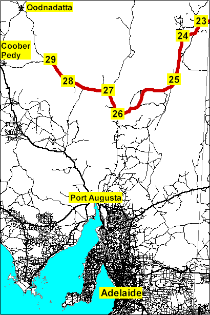
A map of the whole trip is here. The map below shows the route covered in this newsletter, from Innamincka to William Creek.
 |
Legend:
|
The Strzelecki Track, South Australia
 Saturday, 28 July.
With diesel at $1.26 a litre, we didn’t refuel before leaving Innamincka. Our truck carries a lot of fuel, so we knew we could go quite a long distance before we would need to top up. Large signs on the way out of town warn motorists with more normal fuel capacity that the next service station is 460 km.
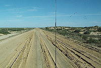 The dirt Strzelecki (pronounced stress-lecky) Track was much better than we expected, wide and mostly not very corrugated, thanks to recent bulldozing. We were expecting to stop at Strzelecki Crossing, where the dry creek crosses the road, however the area didn’t seem to have any great camping sites for a vehicle as high as ours. Most 4WDs would probably find plenty of good places.
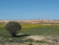
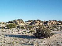
 We went as far as the Monte Collina Bore before stopping for the night. This is in desert dune country, with vegetation stabilising the small sand piles. The country was generally lush and green. Instead of the normal five inches or less of rain per year, last year it had 13 inches, and this year 6 inches in the first 6 months – certainly made a difference to the vegetation. However we saw essentially no animals at all, except for the profusion of bird life near any water.
 A couple of other vehicles pulled up near the bore after we stopped, and most of us put on swimming costumes and sat in the hot water emerging from the bore pipe. Mind you, it was more than a little chilly once you emerged from the hot bore water, or if you ventured away from the bore pipe.
We spent the evening reading. Had it not been so cold (around 4C or 40F), we’d have looked at the stars some more. We had a great view of the Magellenic Clouds. There’s nothing like clear air, no clouds, and no electric lights for hundreds of kilometres in all directions to give one an amazing view of the stars.
Sunday 29 July 2001. We started to see more bird life as we went further along, including a magnificent
wedge tail eagle that flew up from the road as we passed.
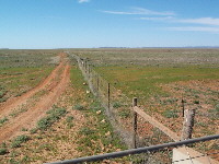 As we approached the dingo fence some very strange older style cars passed us, going the other way. They were festooned with sponsor decals, flashing lights and flags. We stopped to photograph the dingo fence, and more of these vehicles passed. Further down the road, we came across one parked by a light plane that had landed on the road. The cars were all pre-1975 models, doing the Outback Odyssey from Adelaide to Hamilton Island (actually, to Airlie Beach, our home town). They were raising money for the Adelaide Football Club and Crippled Children. Over 40 cars were engaged in this mad enterprise, with support vehicles with spare parts, and the spotter plane for finding lost vehicles.
Lyndhurst, South Australia
We finally reached the small crossroads town of Lyndhurst in early afternoon. Not a lot there, but more than in the previous 500 km. They are at the end of the bitumen (sealed or paved road) going north from Adelaide to Lake Eyre.
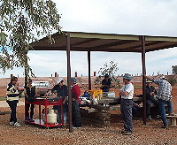 After a softdrink at the pub, we had steak and sausage sandwiches at an outside barbecue run by the Progress Association. They were celebrating someone’s 40th birthday the previous day, and had organised a cricket match in the main street. The party had been going on for nearly two days by the time we arrived.
We refuelled at the general store and service station and camped in the pub’s camping area. Like many outback facilities, the campsite was paid for by donation to the Royal Flying Doctor Service). Eric wandered over to talk with the shearers and fence repairers attending the party and sitting around the giant fire piled high with burning railway sleepers (ties). They were having a great time, except for telling each other they had to get back to the station by four in the afternoon or before the light faded (the last of then left at 10 that evening).
The pub put on a great evening meal, far more fish than we could eat, and a good lot of salad with it, not like in the old days when fresh vegetables were rarely seen this far from the city.
 Monday 30 July 2001.
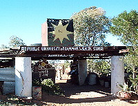
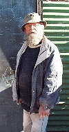
Before we left Lyndhurst, we drove 2 km back towards Innamincka to visit the TalcArt gallery run by Talc Alf. He has been doing sculptures carved from talc, a soft rock, for over 20 years. He is a strange character (“eccentric”), with his ideas on letterolgy (a numerology analogue) and his Republic signs. We bought one of his carvings, since as well as being interesting, it could be used as a paperweight.
Marree, South Australia
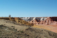 We headed for Marree, but were soon diverted to the ochre cliffs, a magnificent depression of many coloured ochres, less than a kilometre from the road.
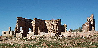 Farina is a ghost town, named for flour, 25 km along the road. It was formed in the late 19th Century and grew to almost 300 people, but never managed to produce the wheat crops planned, as the rains were never as good again in this semi-desert area. It was finally deserted in 1980, and still has the roofless ruins of the old Post Office, one of the hotels, and several other buildings, together with many piles of tumbled stone.
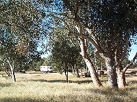 On the nearby Farina station is a wonderful and reasonably cheap large grassy camping area, with shade trees and lots of space between the camp sites. This area has several toilets and a shower or two, although if you want a hot shower you would have to make a wood fire for the brick water heater. It has many barbecues and tables made from railway sleepers (the all-purpose building material in this area now the railway line has been taken up).
In early afternoon we reached Marree, a town of maybe 100 or so, with two general stores (both of which sell fuel) and two caravan parks (owned by the general stores). Marree was formerly the change point at which the fast diesel trains from Adelaide or Port Augusta stopped, and the old narrow-gauge Ghan line to Alice Springs commenced. Eric took the old Ghan back in the early 1970s, and it was a memorable and lengthy trip in the old carriages without air conditioning. The favourite pastime was hurling empty beer cans from the train, as a result of which the entire railway right of way was covered with tin beer cans. Luckily the train stocked a copious supply. The people riding the new air conditioned and sealed carriage trains don’t know what they are missing (nor how lucky they are).
We stopped at the local pub for lunch, then drove to the Oasis caravan park in the middle of town, a whole block away, where a sign on the office door listed the reasonable fees and basically said find yourself a site, and we will be along and collect the fee sometime.
We organised our campsite and paid the caravan park fees at the Oasis cafe, where we also booked a light aircraft flight over Lake Eyre for the next morning. We then wandered about the town, checking the various historical relics and ruined trains at the abandoned railway station. The Marree area was explored around 1840 by Edward John Eyre, who travelled from the Spencer Gulf and reached the southern portions what is now named Lake Eyre. It was originally named Hergott Springs, but has been called Marree since the railway arrived in 1883.
The other general store (on the road to either Oodnagatta or Birdsville) had considerably higher fuel prices than the Oasis Cafe, across the railway line in the town’s business street. It is almost always worth checking for a fuel station off the main road in small country towns. The general store did, however, have some great food, including single-serve cups of gourmet chocolate ice cream.
In the evening, the pilots from Central Air Services were sitting around the campfire with the Oasis’ owner when we returned to the caravan park. They gave us lots of information about the Lake Eyre area. Lake Eyre receives less than 125 mm of rain a year, however it drains an area of 1.3 million square kilometres, over 1/6th of Australia. It is one of the most arid areas in a notably dry continent, and the area is said to commonly reach temperatures over 50 C, and up to 61 degrees.
Lake Eyre flight from Marree
Tuesday 31 July 2001.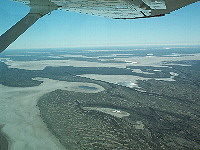 One of the Central Air Services pilots kindly collected us at the store and took us to the nearby light airstrip where we were to fly in a Cessna 206. You can contact Central Air Services at the Oasis Cafe, Main Road, Marree 5733, or phone (08) 8675 8352 or fax (08) 8675 8399.
 We were the only passengers on the 6-seater aircraft. We flew at about 4500 to 5500 feet for most of the flight. We went over some of the cattle stations like the million acre Muloorina Station, which carries about one sheep for each 32 acres and one cow for each 64 acres.
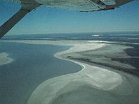
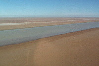
We saw Lake Eyre South, Lake Eyre North, and the causeway between them over the Goyder Channel. The water disappears quickly, as it evaporates at the rate of 2 metres a year. The combined lake is the 13th largest in the world, and the third largest salt lake, holding 30 cubic kilometres when full.
 Lake Eyre North is fed by Cooper Creek and the Diamantina River. It is 144 km long and 77 km wide. It is 15 metres below sea level at its lowest, and averages 3.3 metres below. Indeed, one plane crashed in it, with the pilot apparently intent on flying below sea level. One startling feature of the water is that at a distance it appears blue, as you would expect, however when flying above it, some areas like Jackboot Bay change to a deep red, from the dissolved iron oxides.
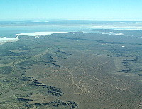 We had an excellent view of the Oodnadatta Track, which passes very close to the South lake. On the return flight we had spectacular views of the Marree Man, which almost fills a plateau 70 km WNW of Marree. This drawing of an Aborigine holding a stick is 4 km long. The largest drawing of a human being on earth, it is five times the size of the Nazca, Peru drawings, and 24 times the size of the English Chalk Hill carvings. It was discovered in 1990, and no-one admits to knowing who made it. However suspicion falls on US and Australian army manoeuvres in the area, and use of GPS navigation and a ten disk plough.
 Jean stopped at the general store-post office to collect her e-mail via the internet cafe there. I think the line was slowish, possibly even 9600, but otherwise mostly worked.
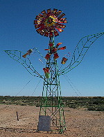
We then headed out of town on the Oodnadatta Track, headed for William Creek. We soon came upon a bunch of giant metal sculptures alongside the road. There were two planes, a windmill as a flower, and many figures, all of metal. Never did work out why it was there or who had created them.
We looked at abandoned railway sidings and eventually stopped for the night at Coward Springs.
Coward Springs, South Australia
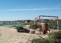
Wednesday 1 August 2001. Coward Springs (S29.24.039 E136.48.869) was another abandoned rail siding on the old Ghan line, now in private hands. It had a small bore dating from 1886 with a small 29 degree spa, and a wetlands from the bore overflow, featuring many birds. The owners had made a very pleasant set of plantings of salt-tolerant trees and shrubs, and had a lot of semi-private camping areas set amongst the trees. We ended up staying two nights, despite having to cook our own meals, because Wednesday turned out to be windy and overcast – a good day to catch up on reading and writing up our trip report.
The campground has toilets and showers, however if you want hot water, you have to make sure you start a fire under the wood heater (known as a "donkey") a half hour before you want the water. No electricity, of course. There is an interesting historical display in the restored old Engine Drivers cottage. The campground owners keep racing camels. http://www.cowardsprings.com.au/
William Creek, South Australia
 Thursday 2 August 2001.
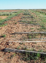
On our way to William Creek, we were amused to see the names and political slogans spelled out in discarded railway sleepers along the way.
William Creek (S28.54.376 E136.20.379) is one of the smallest towns in Australia, with a population of 16. It was named in 1859 by the explorer John McDouall Stuart, after the son of one of his sponsors. The Inland Telegraph Line was installed in 1871, and the Ghan railway came through in 1889.
A freelance photographer, Pete Dobre, was in the pub taking photos. He had just launched his sixth book, of spectacular photos of scenes around Lake Eyre. He told us how he got some of the shots, often involving a dozen rolls of film and waiting half the day for some animal to be in just the right pose. You can visit his website at http://www.petedobre.com.au.
We camped behind the pub, at a cost of $5. They have toilers, hot showers and even a few powered sites. This is a little cheaper than the newer camping area just across the road at the store, which has more modern facilities.
We visited WrightsAir, conveniently a hundred metres from the pub and right across the road from the dirt airstrip. While discussing websites and internet access with the owners, one offered to let Jean use their phone line to grab her email. This was painful at 9600 bps, especially as some company had sent her a 650MB catalogue she didn’t want.
WrightsAir’s flights take in a different part of Lake Eyre than the flights from Marree. http://www.wrightsair.com.au Their website has several pages of detailed information about the area, the lake, and other attractions.
Lake Eyre flight from William Creek
 Friday 3 August 2001.
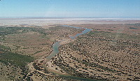 We were up early, in the hope we could get a flight. No wind by 8 a.m. nor any cloud, which is really good. We had a fair wait for the other passengers to gather, as there were now 11 passengers going on two aircraft.
The flight in the Cesna 207 initially took us mostly over land areas of Anna Creek Station, the largest cattle station in the world at over 23,000 square kilometres. We then followed the upper portion of the Warburton groove, where the Warburton River flows into the Lake Eyre North salt beds.
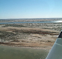 The Warburton was full of bird life, with large flocks of pelicans. The birds and the fish life they live on avoid the southern lake areas once the lakes have water for a while, as the salinity stops the fish. We also saw Hughes Island, another bird breeding ground. It was a great flight.
Continued in Part 4, in which we return home by way of the Birdsville Track and various far-western Queensland towns.
For more information about places mentioned
Two good sites for more information about the places mentioned in this newsletter are Travelmate and Walkabout.