
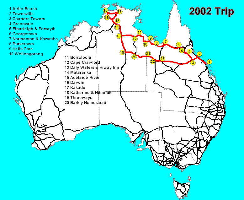
A map of the trip route is here.
Previous installment: Airlie Beach to Karumba. Part 3 (Borroloola to Darwin), Part 4 (Kakadu and Nitmiluk), Part 5 (Katherine and home). Click on a photo to see it full size. Photo album is here.
Note: Some things have changed since we took this trip, so some statements are out of date. We’ve updated many of the links to other information sources, but we haven’t (yet) attempted to add notes on all the other changes.
Monday 8 July 2002.
Getting away from the Savannah Shores in Karumba fairly early, we took on some fuel (at 92.9 cents a litre, the best price we’re likely to see for a long time) and headed for Normanton.
As usual in the Gulf, there was a wonderful array of birdlife around. We don’t have good enough cameras to photo the eagles, as they flap off when you get close. However we saw brolga and jabiru and a variety of other large wading birds.
From Normanton we took The Great Top Road (aka Savannah Way) and headed for Burketown on the dirt road. We were delighted to find that the condition of the road was very good compared to two years ago. We were very impressed to find a causeway across the Alexandria River, where two years ago there was only shattered stones and round river rocks.
 We stopped at the Leichhardt River (18-13.221S 139-62.766E) for lunch; the water appeared to be considerably lower than when we last visited. Two large council water trucks (of the sort used for dampening the dust during roadworks) were doing their best to drain what little water was left in one of the ponds.
 Soon afterwards we were delayed by a large mob of cattle all across the road. We stopped to photograph them, and then after talking with the stockmen, we slowly moved through the mob. Despite this delay, we reached Burketown (17-44.574S 139-32.777E) around 3:30.
The caravan park was only a block from the council office, the pub, and the food store, which was pretty convenient. The space was a little tight for our large vehicle, but the park was otherwise pleasant.
Burketown is on the Albert River, not far from the Leichhardt River. It was named after the idiotic explorer Burke, who in 1861 failed to reach the Gulf, and who subsequently died along with Wills on the Cooper Creek in South Australia (where we were last year).
Ludwig Leichhardt was a naturalist who explored the area in 1844. Burketown promotes itself as a great place to catch barramundi. We don’t fish, but we sure enjoy eating the catch.
The council office had Internet access and the latest city newspapers (otherwise not available in town unless specially ordered in. The most recent Weekend Australian at the council office was over a week old.
The Morning Glory restaurant was closed from Sunday through Tuesday, so we ate at the pub, which has a very nice beer garden out the back, together with a variety of accommodation units.
The Morning Glory, as an aside, is a freak weather condition, a rolling cloud that comes in waves over several days. The cloud extends a considerable distance in length, but is not all that high or deep. Glider pilots seek them out for the experience of soaring using the strong updrafts they bring. We hope to be able to get to the Gulf at some time when they are occurring (said to be generally August to October).
Tuesday 9 July 2002.
We left Burketown a little after 8 AM, on our way via Hells Gate to Wollogorang on the NT border, all of this on dirt roads. After the turnoff from the Burketown-to-Gregory River road, the road to Hells Gate started off pretty well, and we made good speed.
 Tirranna Roadhouse (17-53.745S 139-17.744E), abandoned and vandalised when we saw it two years ago, had new owners who were renovating it. They had drinks and snacks for sale, and said they hoped to have accommodation available soon. They were unsure when, or even whether, fuel would be available, due to the cost of replacing the tanks and the low margins on fuel.
We bypassed the town of Doomadgee and found the road through the Aboriginal lands to be in excellent condition. After leaving those lands, the road deteriorated into major corrugations.
We did pretty well in avoiding most of the bumps, but about 20 km outside Hells Gate we hit the mother of all potholes. Soon thereafter our gear change wasn’t functioning. “Now what do I do?” cried Eric. “Don’t stop!” yelped Jean.
 Running in fifth gear through bad dips and up grades was not a pleasant experience. We did eventually reach Hells Gate, and parked … well, we stopped.
Eric dug out the truck workshop manual, which said that if the gears fell out on excessively bumpy roads, it meant a linkage needed adjusting; the fix was to adjust the linkage. This was complete with the usual incomprehensible (except to mechanics) diagram.
Jean suggested we have lunch while considering our options. She asked the shop attendant if there was a mechanic around; he said no and offered no helpful comments. Later he went on his break, so she asked the new attendant. He said there was a mechanic at the next place, about 50 km up the road. When Jean explained that we couldn’t drive anywhere (since we couldn’t get it into any gear), he turned to another man who had just walked in and asked if he could help.
 This person turned out to be Brian, the owner of the property. He diagnosed the real problem, which was a part of the gear select mechanism was worn, and had bounced out of place against the remaining spring tension. He fixed it for us, and suggested a few kluges until we could get replacement parts. The problem had nothing to do with the fix suggested in the Workshop manual.
Brian refused payment for his assistance, so we left a hefty donation for the Flying Doctor as a token of our gratitude. More about Hells Gate from Savannah Guides.
At about 1:30 we continued on very cautiously the 52 km to Wollogorang Station (17-12.703S 137-56.832E) over a road that was in patches as bad as anything we have ever encountered. It took corrugations to a new height, in every sense. We got there around 3:30 and booked in for the night. Well, Brian at Hells Gate had said to us “The road is a bit corrugated.” We’ll have to remember to allow for country understatement. Brian also said that within 5 years the entire Great Top Road should be bitumen. I suppose we’ll one day be saying with pride, “we drove it before it was paved” but right now we wish we’d waited!
(Before leaving on the trip we’d checked with some other CMCA (Campervan and Motorhome Club of Australia) members about the condition of the road, as they said they had travelled across it a few weeks before. We were told, “If you take it easy, it’s not too bad.” By this time we were wondering what they thought was a bad road, but we also knew that even a week can make a lot of difference in these roads: the traffic can change them from quite acceptable to totally ghastly within mere days.)
Wednesday 10 July 2002.
Today we had well over 260 km to go from Wollogorang to Borroloola, over a road reported to be worse than anything we have done to date. And it was. We won’t list here the miscellaneous minor bits that were shaken loose, many of them fixed with duct tape.
Around midday the gear selector failed for the second time after a severe set of corrugations. At least this time we knew what to do to fix it.
 Not long after we stopped and raised the cab to let the engine cool, a couple we’d met at Wollogorang came along, and Cec kindly assisted with tools for the repair after we each had lunch by the road. Cec also supplied the baling wire I used in an attempt to keep the mechanism in place (see photo).
Cec and Holly then kept an eye out for us about every 30 km further down the road, to ensure we had made it that far. We are very grateful for their support. Although there was a fair amount of traffic on the road at various times, no one else came along during the 2 hours or so we spent fixing the truck.
(We are reminded of Collyn Rivers’ comment to the off-road truck enthusiasts at the CMCA Rally in Barcaldine, while discussing some obscure track across one of the deserts, “It’s a well travelled road; you’ll see at least 3 or 4 other cars in a day.”)
The last 100 km into Borroloola (much of it through Aboriginal lands) was in significantly better condition than the earlier stretches, and we reached the town (16-04.174S 136-18.436E) just before 5 pm.
Ben and Vicki, CMCA members who live there, had invited people to visit, so we had phoned to say we were coming. We booked into a nice site at the caravan park and were just about recovered from the day when Ben turned up unexpectedly to drive us to their home for a great barramundi, salad and chips feast. Another CMCA couple were there too. Dinner was followed by interesting conversation until fairly late.
Thursday 11 July 2002.
We spent the morning goofing off and recovering from the past few days’ experiences. The local service station was out of fuel (they had been rationing it yesterday). Although we wanted to refuel, because Borroloola has the best prices for several hundred kilometres in all directions, we weren’t desperate so we didn’t worry.
We had lunch at the local pub, which has a pleasant lounge area. While there, we noticed that a fuel tanker had arrived at the service station nearby, so after lunch we stationed ourselves nearby, ready for our turn to take on fuel.
Then we moved the motorhome over near Ben and Vicki’s home, and Ben turned up and left us comfortably downloading e-mail. We stayed the evening parked outside a nearby house.
Next installment: Borroloola to Darwin, in which we see some really great countryside, have many enjoyable moments, and endure more things going wrong with the truck.
For more information about places mentioned
Two good sites for more information about the places mentioned in this newsletter are Travelmate and Walkabout.