These notes were written by Eric and amended by Jean. Eric took most of the photos and Jean took others. All photos were selected, cropped, and inserted into this file by Jean. Factual information was taken from various sources including tourist brochures; we do not guarantee its accuracy.
Click on a photo to see a full size version. Not recommended for readers on dialup connections — some of these files are between 1 and 2 MB. Photo album from this part of the trip (more photos than shown on this page) starts here.
Thursday 12 February: Skippers Canyon
Skippers Canyon, a gold rush area in the Mount Aurum Recreational Reserve, was our morning tour. Adam of Nomad Safaris met us promptly at 8:30 a.m. at our hotel with a 4WD. He also picked up four more people from a British tour group in town.
A short distance by road, past the Shotover River jet boat terminal below the road bridge. These are the famous jet boats you see so often in tourist photos. We climbed the heights surrounding Queenstown, and ran into cloud.
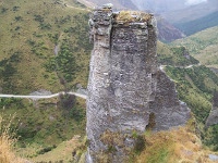 We eventually turned off on a dirt road. This became a worse dirt road past a sign warning hire cars were not covered by insurance past this point. It eventually became an outright dangerous mountain track. The road into the Shotover River valley was cut by contractors for the gold mining companies along 14 kilometres of steep hillside and sheer cliff through the mountain. It was all built by hand, with the 14 kilometres of track taking 7 years to complete.
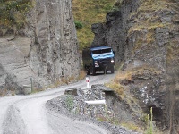 The short Hells Gate through rock took the road crew three months to cut. A short distance further on is Heavens Gate, about the length of our Landrover. This took a mere one month to cut. Bus Scratch corner has an overhang such that any vehicle wider than average is scraped along one side trying to keep its tyres on the road.
The road has no crash barriers. At many places you look directly down a drop of from 100 to 400 metres to the river valley far below. For historical accuracy, the road really can not be modernised. Just the drive itself is an experience—especially if you meet a vehicle coming the other way.
We passed a few homes of hardy individuals. One gold mining pair moved to the edge of the canyon to be closer to town, and lived there until in their eighties.
There have been about 20 hotels along the way. The Welcome Home Hotel lasted from 1908 to 1942, despite being burnt down and rebuilt in 1930. The decline in gold mining eventually closed it in the late 1940’s, when it was demolished. Today only a chimney and a few foundation steps remain.
There are former bungee jump points. Pipeline bungee crosses the canyon at a height of 102 metres. It was replaced by a point offering 135 metres. Just a coincidence that a pipeline happens to have sufficient framing strength for bungee jumping, plus a convenient foot way across.
An old Australian mining dredge was lying rusting in the river. It was imported, but without the bolts. The miners made do with welding. However the adjustments that suited Australia were not able to be altered once it was welded together, and it never did work correctly. It was eventually destroyed by a flood.
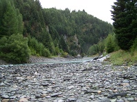 We visited one of the places filmed for the Ford of Bruinen scene in Lord of the Rings. Our tour guide Adam explained that the water was too deep for horses. The actual river was photographed elsewhere, and the water and riders added to the scenery.
We saw jet boats on the river several times. They can plane in 10 centimetres of water.
We crossed the 1900 suspension bridge that gave access to the former township of Skippers. Parts of the old settlement are being restored by the Department of Conservation. The Upper Shotover Public School 1879–1927 restoration is a fine completed example at the site, dating from 1992.
Mount Aurum Station homestead is at present being restored by a crew from the Department of Conservation. They spend about two weeks at a time on site doing repairs.
When we broke for morning tea we were pleased to notice two new picnic tables on site had been donated by Nomad Safaris. Adam also took all the leftover picnic supplies over to the work crew.
We did some panning for gold, like the old prospectors, except we did not have to carry all our supplies in on our back or by horse. Adam dug up some riverbank rocks near the end of the Skippers Canyon Run jet boat hut. We tried to imitate how he swirled the water around to throw off the lighter rocks. It sure is hard on the back, even for one pan full. One of the group had some tiny specs in the bottom that looked like gold.
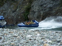 The jet boats came by. Gave their paying passengers a bit more of thrill by trying to splash us poor downtrodden prospectors. Luckily Adam had warned us of their little tricks, so we pulled back from the edge of the river. The jet boats sure put on a spectacular performance. The water where they did this trick is really shallow.
Afterwards it was the interesting and potentially terrifying drive out of the canyon again. This time we did meet traffic coming down the one-lane track. The lack of clearance made things interesting, with very little room for error when backing to a wider part of the track to allow passing.
The cloud had lifted somewhat, so we stopped overlooking the Queenstown area for some photographs. Since it was still misty, this was somewhat lower than the usual lookout spot. Still a spectacular view.
We returned to Queenstown around 12:30 p.m. and collapsed at the Bella Vista motel. We ran the heaters until we were warm again, and tried to dry out our shoes. Later in the early afternoon we managed to walk into town for lunch.
Some of our fellow passengers had raved about the British style fish and chips at Speights Ale House, so we went there for lunch. It turned out to be just around the corner from Brazz Bar where we had dinner last night. Speights was less expensive, and if anything even more filling than the nearly overwhelming quantities at Brazz.
Jean had the Blue Cod with chips and salad, and a glass of Speights Pilsener. Eric had Porter flavoured sausages and mashed potatoes, with caramelised onion, and a pint of Speights Porter. The bitter burnt malt beer went well with the traditional English bangers and mash. Had we not still been full at dinner time, we would have returned for dinner. We took the remains of a sausage with us for a snack later.
We eventually staggered around town taking in the sights at the short mall and the other relatively quiet street leading from the lake.
Rain threatened, and clouds were low over the town. Most outdoor activities seemed less than likely. Jean took a nap, and Eric tried to bring these notes up to date with help from the latest photos.
Adam has pointed out a deli and food market nearby. Eric went there, but arrived only a few minutes before it closed at 6:30 p.m. He did manage to get a banana to go with our breakfast cereal, and a bread roll.
We had a late dinner (for us) of the remains of a half sausage from lunch, on the bread roll. Plus a small glass of the Pinot Noir. Jean also had a little of the Brie Eric got for her yesterday. He had a chocolate drink. New Zealand motels are absolutely marvellous about supplying chocolate drink mix as well as tea and coffee. We wish more Australian motels managed that.
Friday 13 February: Queenstown to Haast
Late arising, around 7 a.m., despite an early night. We seemed slightly more organised as a consequence. Emphasis on slightly. We were away at 8:30 a.m., headed towards Cromwell and ultimately to Haast on the West Coast.
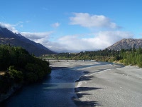 We stopped at the Old Shotover bridge reconstruction around 9 a.m. and took some photos. Although pedestrian only, it is an impressive structure, much higher than the new concrete road bridge. We were surprised by how biting and cold the wind was across the bridge, and were pleased to get back to the warmth of the car.
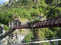 Further out of Queenstown we came across the A J Hackett bungy jump operation at Kawarau Gorge. This includes a modern concrete building (a bit of a maze if you enter via the elevator) with souvenir shop and bar. There is an impressive range of free viewing platforms from which to watch insane youngsters pay lots of money to leap off a perfectly good bridge. Luckily Eric’s heart and Jean’s cyborg hip implants prohibit either of us from even contemplating such activities. It did not stop us taking photos of the impressive scenery.
Our three-hour 210-kilometre journey actually took over 7 hours, and was over 250 kilometres.
At Nevis Bluff we encountered a road crew preparing some impressive cliffs for blasting to clear potential rock falls. The sign said a 20 minute display. It was at least that. At least they were not doing the actual blasting as yet, which starts in a week and lasts eight weeks.
We drove into the popular tourist town of Wanaka, and found it nigh impossible to get a parking spot. We finally found a 30 minute parking spot. Traffic was busy. We settled for getting a Subway club take away to share, and making our getaway as quickly as we could.
We eventually ate our take away submarine sandwich overlooking Lake Hawea about 12 km up the road at around 12:30 p.m. Far more peaceful, and way better scenery. However the wind off the lake was cold and constant. There were several large rocks on the picnic table, as aids to tourists seeking to hold down paper wrappings.
 Further up the road the scenery just kept improving and improving. We made several stops to take photographs. Jean even risked a steep embankment to get good views of the lake. She then had to scoot down the embankment by sliding on her backside, since it was too steep for her to walk.
Further along, we left Lake Hawea on our right, and again reached Lake Wanaka, on our left. It sure is a long lake. We were still taking photographs after 1:35 p.m.
Makarora was our ice cream stop. Jean played it safe with a wimpy pale chocolate ice cream. Eric was daring, and had his very first Kiwi fruit flavoured ice cream. Strange, but good tasting. He does not expect to ever have another chance to have Kiwi fruit ice cream.
Haast World Heritage Hotel was our location for the evening. On Route 6, past the turnoff for Haast. It has a pleasant aspect, and we were settled in our room around 4 p.m. Alas, the washing machine in the guest laundry was broken, so no laundry for us today. We are three days from running out, so no big deal yet.
Internet connection is via a satellite, however reception explained that on cloudy days it was slower than dialup, as you would expect. One computer in reception, one in the foyer of the bar. Eric checked the WiFi connection while at reception, and his iPhone could only fleetingly pick up one bar from the antenna nearby. Give that a miss.
The dining room was not open on Friday for dinner. The Frontier Cafe Bar is open from 11 a.m. until late. We suspect they may mean until real late. Eric was able to sample one of their draft Speights ales.
Haast is not on the national power grid, being supplied via a hydroelectric station about 35 kilometres away. The hotel handbook warns of power outages. Reception say power is mostly fine. The hotel say that as a result of this power supply situation, they do not supply bar fridges in the room. Horrors! We were forced to drink all the white wine before it got warm.
We were also amused to note that daily newspapers do not arrive until the afternoon of the day of issue. This sound just like some remote areas back home in Australia, except that it was often next day, or even once a week.
We shared a dinner at the Frontier Cafe, since Eric had been forewarned they were gigantic. Eric had tomato soup, Jean had fish and chips. The meal nearly defeated the two of us. Luckily we arrived early, at 6:30 p.m., as the bar was already almost full. Nice food, washed down with Speights Ale.
Saturday 14 February 2009
North Coast drive for us, with a tour deadline before 1 p.m. So we were up early, after an early night. We strode to the Haast World Heritage Hotel restaurant right on 7 a.m. One harassed looking person was just opening the door as we reached it. The chances of a cooked breakfast rapidly evaporated. We decided we would make do with a Continental breakfast. It turned out that the cook was also the receptionist, as Eric found out when he went to settle our account. We got the car packed and were out the door before 8 a.m.
We needed fuel, and the 24-hour petrol station was just opposite the hotel (at least, it had a 24 hour card-operated pump). There was a queue, consisting entirely of 4WD vehicles towing trailers that held jet boats, each of which needed fuel for both vehicle and boat. Blocking them were two motorcycles. We finally got fuel and were away from next door to the hotel by 8:15 a.m.
The road north was mountainous and twisted. The two-hour estimate for covering 176 kilometres seemed less and less likely. This seemed typical of New Zealand. Our first photographic stop was at Knights Point lookout at 8:50 a.m. By 9:20 a.m. we were averaging about 50% slower than estimated. This also seems typical for New Zealand.
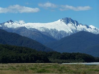 Fox Glacier turned out to be only 4 kilometres off the road, when we reached the turnoff at 10:15 a.m. (we had done 120 kilometres in three hours). Jean was enthusiastic about seeing the glacier, so we drove the gravel road to the parking lot. Yes, the parking lot was 4 kilometres … well, closer to 5 kilometres actually. On the way, we passed a sign saying the glacier extended there in the 18th Century. Another sign showed where the glacier had been in the 1930’s.
The walking trail to the glacier said 5 minutes. That was to a point at which you could photograph the glacier. We continued on for a considerably longer distance. Eventually topped a rise that gave us an even better view of the glacier, and the long slope we needed to negotiate on rough ground. At that point we headed back to the car, rather slowly. Well, very slowly. We managed to get away from the Fox Glacier turnoff around 11 a.m.
We went straight past Franz Josef Glacier turnoff around 11:40 a.m. No time for another 40 minute or so walk, because we had a tour scheduled for 12:45 p.m at Whataroa. We arrived in plenty of time to get a meat pie each for lunch, at the general purpose store across the road.
Whataroa was an interesting little place. The Maori stone and wood carving store there had some wonderful examples of Maori art. I do not understand the culture, but there must be a fascinating story behind each piece.
The 3-hour tour to the White Heron (Kotuku) Sanctuary at Okarito Forks started with a 14 kilometre drive through pleasant rural countryside. The driver was no conversationalist, but he played an interesting and well done CD explaining the tour and giving examples of various bird calls.
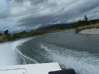 A jet boat ride down river to the sea was next. It was not intended to be an edge of the seat experience, but there was plenty of shallow water, rocks above the surface of the river, and a twisted and winding river. So the ride was fun, if you like banking into turns and sliding across the water. Eric loved it.
The short boat ride up the heron sanctuary river was sedate, especially by comparison. After creeping along for a while, we moored at a jetty and followed a well maintained boardwalk for 500 metres through rain forest. Plenty of tags explaining which tree or fern was which. The White Heron Tour guide (our boat driver) was very well informed. No question seemed to stump him.
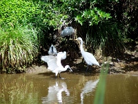 There was a large two-level hide just across the narrow river from the white heron colony. Plenty of room for the six of us on this tour. The only colony of nesting white herons (Kotuku) were sharing this small stretch of the riverbank with white Royal spoonbills. There were also some black little shags or cormorants drying their wings in the sunlight. Some of the rare white herons were wading by the river bank. Most were nesting in trees. They were of several sizes, from fully adult down. One was caring for two young.
We were back at the White Heron Tour office by 3:37 p.m. Then on 100 km or so to Hokitiki for the evening. Do we need to mention curved and winding roads, with the odd lake for scenery?
Google maps took us right to the waterfront location of Beachfront Hotel Hokitika on Revell Street. Our room in the new wing was rather nice, with the promised water view over the beach to the Tasman Sea. It was also a large room, not crowded despite a King bed and a large single, plus a large wardrobe and a long sideboard. The room not only had a desk and chair for business use, but two comfortable lounging chairs.
The dining room looked good also. Today it had a mildly expensive set menu, with a choice or two of each item, or a very expensive Valentine Day special menu. Eric did not think either totally appropriate. Jean was so tired she would eat anything, anywhere, as long as it was easy and now.
We had dinner next door, at a small cafe. Steak for Jean, a BLT for Eric. Their house red was pretty acceptable, and they had Speights Golden Ale. Still more food than either of us could manage to eat. Plus the price was about the same as a single two course meal at the hotel.
The hotel did not have a guest laundry, but did offer a $10 bag wash. That was even easier than doing it ourselves. Less time taken for us.
Eric took a wander around the tourist town of Hokitika later. More jade factories and outlets than he thought possible. He also noticed two shops selling books. A Kiwi experience promised live kiwi. The local cinema offered the remake of The Day The Earth Stood Still, and he was tempted, buut too tired from the driving. Instead he sat up writing these notes.
Page last updated 7 July 2009.
