
August 2003
(Click on photographs to see a larger version. Note: Some file sizes are quite large; not recommended for people using a dial-up connection.)
We’re usually not keen on organised tours, but occasionally something turns up that we simply could not do on our own. This 14-day expedition included stops at several places that require permits or special permission to enter, and some that are only accessible by air.
 The expedition was organised by Sydney lawyer and bushwalker David Marks, who has been doing this sort of thing once or twice a year for 20 years. We travelled in two chartered 10-seater Piper Navajo Chieftain aircraft. This is much like a bus tour, but with views from much higher, as well as faster travel, and access to area difficult to reach by land.
The trip was awesome. Words (and even photographs) are not really going to convey the experience, but we’ll do our best. For further information about these expeditions, see http://www.dreamtimebyair.com.au/ — note that the itineraries shown on the website are examples only; each year’s trip is somewhat different, and this year’s was very different from anything shown on the website.
A bit of background:
We had a 12 kg weight limit for everything we took with us. Lots of that needed to be reserved for stout walking shoes, plus shoes for very wet areas, and of course for cold weather clothing in addition to shorts and t-shirts for the tropics. We left behind all the computer gear except for Eric’s small Psion palmtop; although we expected to find electricity available in most places, we didn’t expect to have phone or Internet access very often, nor the time to do more than take a few notes. Jean took her CDMA mobile phone, which did work in more places than Eric’s GSM phone, but used it only once, in Darwin, as well as picking up a few messages.
More than half the group were over 65 (two were 80). The seniors were quite impressive, as they turned out to be easily capable of walking and climbing further than Jean (at 60) can manage.
Here is a map of where we went. The numbers correspond to the days in the trip report.
Day 1, Monday 11 August: Sydney to Arkaroola, SA
We departed from Bankstown airport in Sydney at 7 AM. Soon after takeoff we encountered cloud, and so didn’t see much on the ground, until way out amongst the carefully geometric fields around Griffith, NSW.
Our first refuelling stop was at Griffith, where champagne, cheese, crackers and dip were laid on at the local aero club.
 Afterwards, we cruised towards our next stop, Broken Hill, in sunshine, but with cloud below us. The ground changed from irrigated farm to a more typical Australian red earth. Even so, we were surprised at how much vegetation was visible.
After Broken Hill, we passed over Lake Frome, and were surprised by the water in the salt lake bed. We’d have expected it to be dry, like so many other salt lakes we have seen. Looks very dry except around river beds, with isolated scrubby bushes evident.
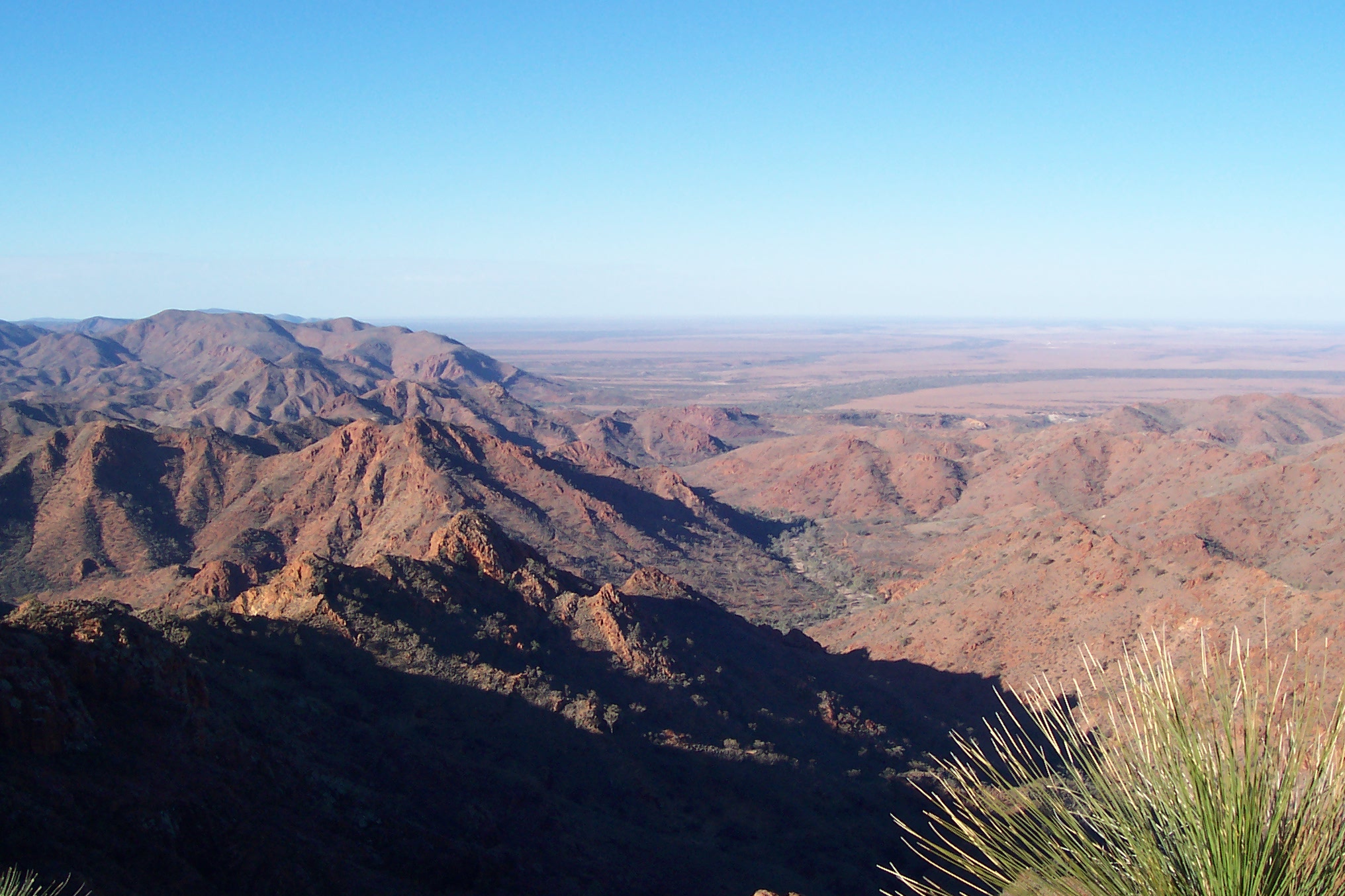
 We came within sight of the Gammon Ranges, a far northern section of the Flinders Ranges in South Australia, and landed at Balcanoona aerodrome. The facilities there are a bit limited, being the bitumen strip and a windsock.
Gammon Ranges National Park covers 128,228 hectares, 750 km north of Adelaide, 110 km east of Leigh Creek. The park includes a rugged wilderness of mountains, gorges and inaccessible country.
The 35km trip from the aerodrome to Arkaroola Resort took us from flatland through rolling hills, and finally into rugged mountains. We saw some wedge tail eagles in the distance.

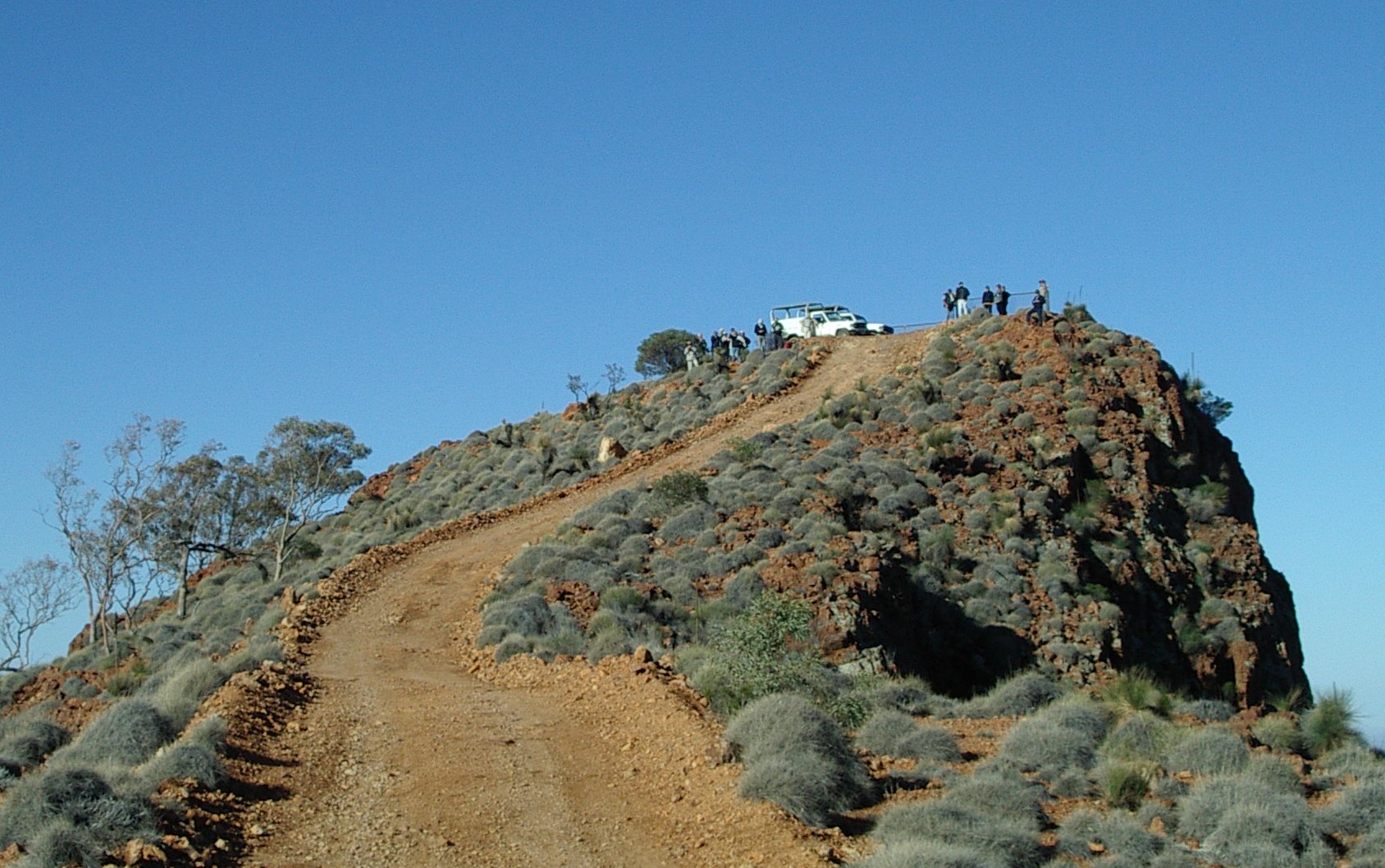 In the afternoon, we took a ridgetop tour in purpose-built 4WD vehicles through the arid red ranges of the Mt Painter Sanctuary. This 42km trip covers some really rugged mountain terrain.
We saw mountain goats and euros (not the currency), grazing by the track. Euros look similar to kangaroos, but their faces are more doglike.
 We stayed at the Arkaroola resort overnight. Arkaroola Village, PO Box 125 Upper Sturt 5156, phone (08) 8648 4848. The Arkaroola Resort and Wildlife Sanctuary is a 610 square kilometre property. In addition to the ridgetop tour, 3 other guided 4WD interpretive tours, 5 self-guided walking trails and local scenic flights are also available.
The rooms (at least those we stayed in) are basic, but comfortable motel-style units with ensuite bathrooms and electric blankets — most welcome on a cold winter’s night. http://walkabout.com.au/locations/SAArkaroola.shtml
 Arkaroola is one of the best places in the Southern Hemisphere for viewing the stars at night. A large astronomical observatory offers an expert nightly tour.
Unfortunately the combination of a full moon and cloud cover meant we were unable to observe Mars (almost at its closest approach to Earth) and other astronomical features. Instead, we had an interesting talk by Doug Sprig on the geography of the region, illustrated by a large satellite photograph.
Day 2, Tuesday 12 August: Woomera and Coober Pedy
Rain overnight (for the second day in a row, but the first rain in 6 years, we were told) made walking to breakfast through the puddles an adventure. Even more exciting, we weren’t sure we would be able to leave. Was the road open? Was the airstrip usable? Eventually the rain stopped and we set off, only a bit late, and had no problems with either the road or the airstrip, but it did serve to remind us how quickly things can change and how flexible one needs to be when travelling in remote areas. (16 mm the previous day, and another 7mm overnight.)
 We left Balcanoona airstrip finally, around 9 AM, and overflew the Gammon Ranges and Lake Torrens salt lake, second largest in Australia (south of Lake Eyre), on the way to Woomera.
 At Woomera, we started at the Heritage Centre, which had a small museum and a shop, opposite a park containing examples of many of the rockets launched from Woomera. The Heritage Centre also featured a 2-lane tenpin bowling alley! Phone 1800 633 060 http://walkabout.com.au/locations/SAWoomera.shtml
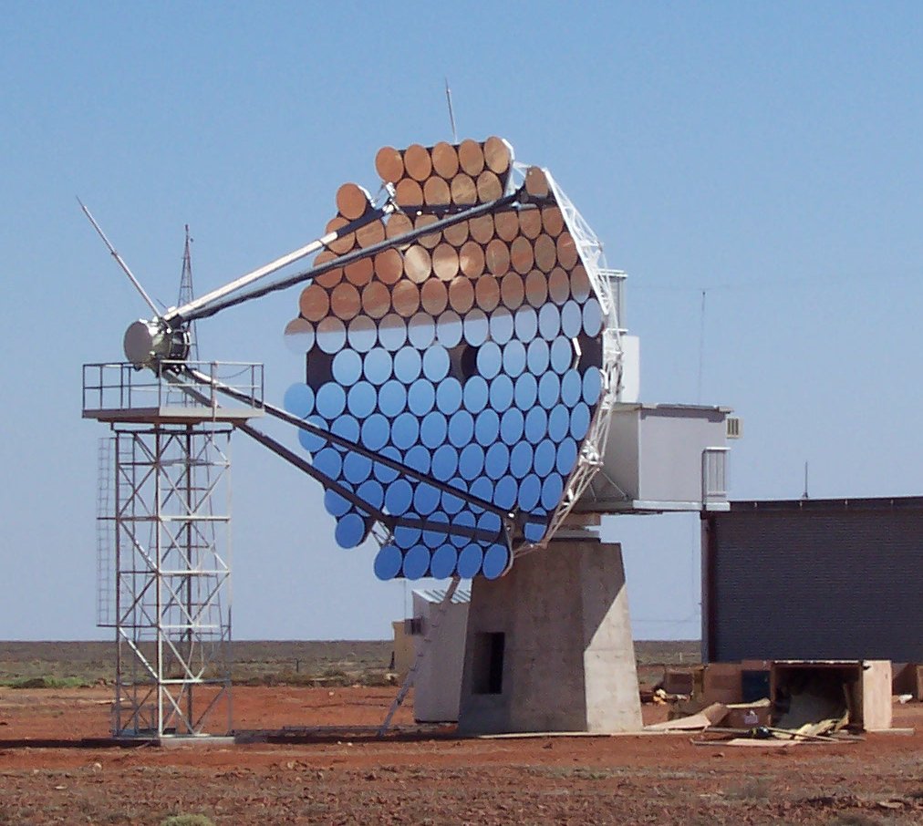
 We had a splendid vehicle tour of Woomera rocket range, including many of the restricted areas. Woomera was established in April 1947 by Britain and Australia as a Long Range Weapons Research Establishment, and was used for rocket launches and as a weapons test area. It is still the largest land test area in the world. The town was opened to the public in 1982. More recently, Woomera has been in the news because a detention centre for boat people was established there, and radioactive waste is stored in one disused rocket-launching area. The detention centre was not in use when we visited, but it wasn’t on the tour. At Range E we couldn’t photograph the water tanks, security post building, or the low level radioactive waste store from Lucas Heights. but we were able to photo the radio telescopes, reflecting earth and sky ininverted imultiple mages, and the abandoned ELDO launcher.
We finally got away from Woomera around 2:45 PM, stopping to refuel at the tiny Olympic Dam airport (Roxby Downs), as avgas suitable for our planes was not available at the large and fancy Woomera airport.

 We arrived at Coober Pedy very late, snapping photos of the piles of excavated earth surrounding airport and town as we landed. We set off on a 2-hour 70km bus tour, passing through the mine field. Our guide told us a 50 by 50 metre 3 month lease cost $20. Miners dig a hole. If opal shows, then they dig a mine. If no opal, they dig another hole. http://walkabout.com.au/locations/SACooberPedy.shtml
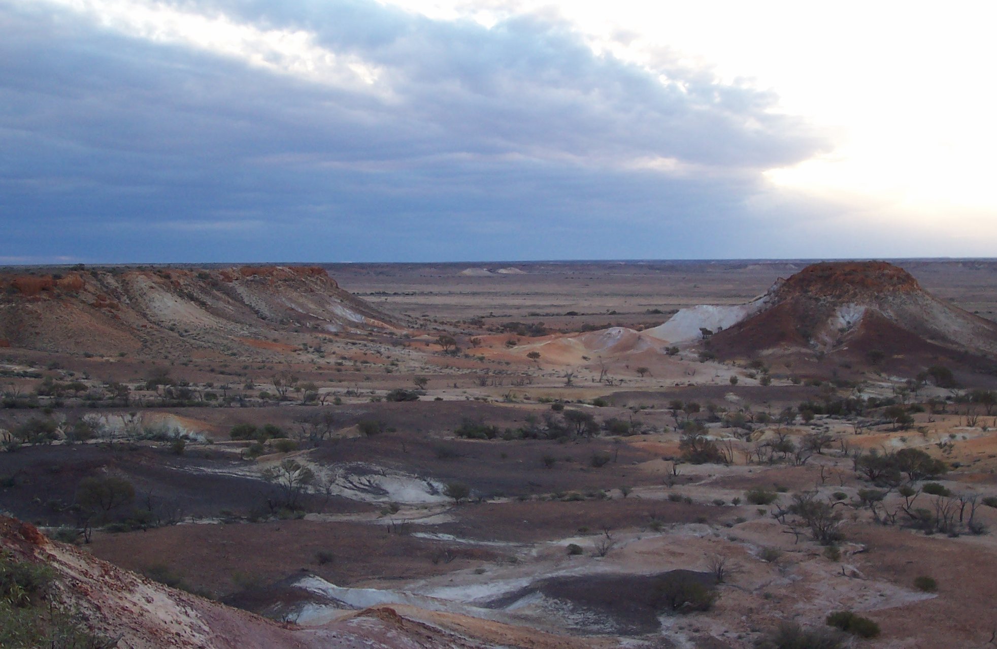
 We visited the Breakaways, Aboriginal land 30km from town, a set of flat-topped mesas at the edge of an ancient sea. If you saw Priscilla, Queen of the Desert, this is where much of it was filmed, including the scene where the drag queen rode on the roof.
On our trip we passed the local golf course, where there is not a blade of grass on the fairways and the greens are oiled sand.
 Coober Pedy means white man’s hole in the groun; the Aboriginal term is kupa piti. This town of 2800 (3500?) people supplies 80% of the world’s opals. Many buildings are underground, to escape the extreme summer temperatures.
 We stayed overnight at the Desert Cave Hotel, PO Box 223, Coober Pedy 5723, phone (08) 8672 5688.
 This 4-star hotel has all mod cons, including a sauna, spa and pool. We were lucky to get one of the underground rooms, which featured incredibly colourful rock walls. It was most comfortable.
The restaurant was above ground, but the bar was underground, as was a gallery showing the excavation and mining work.
Last updated 4 October 2007.