
Note: Many things have changed since we took this trip, so some statements are out of date. We’ve updated many of the links to other information sources, but we haven’t (yet) attempted to add notes on all the other changes.
Continuing our trip to Lake Eyre, South Australia. After our successful visit to the Lake, we returned home by way of the Birdsville Track and other places in Queensland.
The first three instalments of the trip are here: Part 1, Part 2, and Part 3.
Maps of the trip are here.
Lake Eyre, South Australia
Friday, 3 August.
At the end of the previous installment of this trip report, we had just finished a wonderful flight from William Creek over Lake Eyre, South Australia.
Upon our return to William Creek, we lunched at the pub, and then set out to drive back to Maree. We had considered continuing on to Oodnadatta, but apart from the Painted Desert, it didn’t sound sufficiently attractive to bounce along several hundred more kilometres of rough road. Also, you can do the Painted Desert easily from Coober Pedy on several local tours like the 4WD http://www.desertdiversity.com tour, or do these towns by camel safari http://www.austcamel.com.au/explore.htm. You can even take a day trip on the mail run.
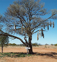 Just outside William Creek are two trees with dead animals hanging from them. One has a collection of foxes and a sign saying “Foxtail Fir”. The other has cats and a sign “Pussy Willow”. They are testimony to the problem of feral introduced predators which have caused so many Australian animals to become endangered or extinct.
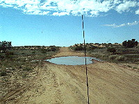
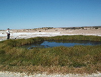 On the way back to Marree we drove into the Strangways siding, an old ruin from the days of the Overland Telegraph line. We also stopped at Blanche Cup mound spring in the National Park. This is a mud hill produced by an artesian spring, and forms a large mound with a pool at the top, surrounded by vegetation. This is a great example of the type.
Further down the road we came upon some German tourists photographing one of the spade tailed lizards crawling across the road. It eventually found the side of the road and (relative) safety. This reminded us that we’d seen almost no reptiles on this trip, though no doubt many were around.
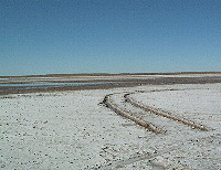
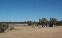
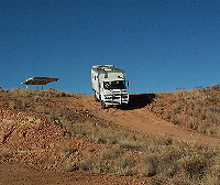
The big event of the afternoon was a stop at Lake Eyre South, where the road comes quite close to the lake. You can drive almost to the edge at several places, though the tyre ruts made it clear that you had to be very careful not to get bogged in the mud. (We’d heard several stories of people having to winch each other’s 4WDs out, often getting bogged themselves in the process.) Considering the weight of our vehicle, we decided to be quite conservative, so we parked a considerable distance from the visible water and walked the rest of the way. The area was a maze of footprints, some fairly deep.
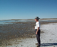
 After walking across several hundred metres of dry mud and squelching through wet mud for 20 metres or so, we reached an area with a thin film of water on it, and little pools in the footprints. We dipped our fingers in the water and contemplated the view. (Eric tasted the water: very salty; no surprise there!)
We eventually got back to Marree, where we refuelled and stayed a couple of days at the Oasis caravan park.
We dined on roast beef at the pub, as usual, and were impressed to find there had been a vegetable delivery recently, as the vegetables were crisp and plentiful, not limp like the last time. We shared a table with another couple, who were gathering information for a film feature they hoped to sell to TV, in preparation for next year’s Year of the Outback tourist promotions.
Marree
Saturday 4 August 2001.
On our previous visit, we had worked out how to use the showers at the caravan park, to avoid getting our pants legs wet. Wearing shorts helps, but a better tactic was to dash for the showers in bath robes, and get dressed back in the motorhome where the floor wasn’t wet. Some caravan parks have better designed showers than others, and most are more like this, at the pathetic end of the scale.
So we goofed off for the day, read our books, and collected some supplies for the rest of the trip. Jean had another session on the slow internet connection.
Lunch was giant salad sandwiches from the Oasis cafe, while dinner was another roast at the pub. Our table companions this time were a mad keen fisherman and his wife. They had set out to see Oodnadatta, and had managed that. They now planned to visit Birdsville the next day, and return the following day. They were smart, however, and phoned ahead for a hotel room at each stop.
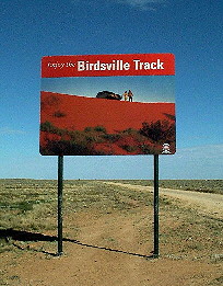
Marree to Mungeranie
Sunday 5 August 2001.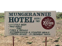 We headed off on the Birdsville track, which was actually in pretty good shape. A sign near town mentioned several places where camping is allowed along the way. (The track goes through a lot of private property, and the owners don’t like people camping all over the place, probably because a lot of people leave a mess behind, thus giving all travellers a bad name with the property owners.) Another sign assured it we had only 200 km to go to the next pub!
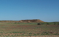
 Since we weren’t planning a long drive, we stopped at every point of interest along the way. The Lake Henry ruins, a mesa 30 kms from Marree, and another set of ruins so collapsed we were initially unsure we had located them.
The Clayton Wetlands camping area 53 km from Marree now had a pair of the new toilets that are being installed in lots of remote places. A wind powered fan, and a solar panel and timer controlled battery light for night. You could camp anywhere within a kilometre of it. The camp area had nice shade trees and a fair bit of fallen timber for fires. If we’d been taking a more leisurely trip, we probably would have stopped there for the day.
We continued on to the Cooper Creek camping area about 140 km from Marree for lunch. It was much the same as the Clayton area, except that Cooper Creek appeared dry here. We ate lunch and took a nap before driving on to Mungerannie, about 206 km from Marree.
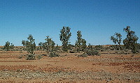
 The countryside was very interesting, with vegetated sandhills and stony flat areas (thus making it quite clear why this is called the Stony Desert). All with small green growing plants, many with tiny yellow or white flowers.
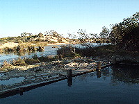
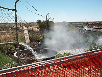
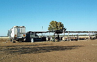
Mungerannie (S28.01.204 E138.39.824) is a station that now provides a bar and food stop, plus excellent showers and toilets and a large open rest and camping area. The small wetlands here are fed by an artesian bore about 3 km away. This water emerges at about 86 degrees C, and it is still almost too hot to touch when it comes from the pipe at the large spa pool provided. Naturally you do have a lot of sulphur smell from it (and the showers, which use the bore water), and you certainly wouldn’t want to attempt to drink it.

 Monday 6 August 2001.
We stayed at Mungerannie for the day, since it was nice and peaceful. We watched a couple of tour buses arrive and provide lunch for their (mostly grey) customers. One bus was doing a trip from Gosford via Hay, Marree, Birdsville, Innamincka (the Birdsville to Innamincka track is one we wouldn’t do, given the reports we have of it), Camerons Corner and back to Gosford on a 12 day tour. The other was headed for Alice Springs and then Darwin via Birdsville, Boulia and the Plenty Highway on an 18 day trip.
We met our dinner companions from Marree on their way back from Birdsville. Some people travel a lot faster than we do. Then we sat in the spa getting overheated for a considerable period of time towards late afternoon.
Mungeranie to Birdsville
Tuesday 7 August 2001.
We were in no rush to leave, as we planned to stay at a camping spot only a hundred kilometres up the Birdsville track, where the old inner track (along the creek) separates from the new longer outer track. (It was listed as one of the permissable places to camp on the track.)
 We got away at 10 am, on a reasonable dirt road. This degenerated past the road construction zone, and there were several minor water obstacles, suggesting there had been local rain recently.
Alas, we couldn’t find the camping area. We had a fair idea where it should be, and that area seemed sandy or muddy, or both. Although we didn’t really want to continue on to Birdsville, about twice as far as we were hoping to travel that day, we did so, arriving only a little before 5 pm. Just before town, we crossed the border from South Australia back into Queensland.
Birdsville
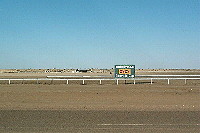 (S27.01.585 E139.11.146) We looked at the famous Birdsville racecourse, where the annual races would be held the first weekend of September. http://www.birdsvilleraces.com
We continued across the Diamantina River to the caravan park. Within 15 minutes of booking in and parking, the Census collector had tracked us down and given us our form (this was Census night). We had hoped to be missed by camping in a remote spot. Curses, foiled again.
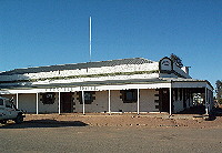 We headed to the famous Birdsville pub for a $10 roast beef dinner that couldn’t be beat. We ate in the bistro area, but the pub also has a nice restaurant with paintings by a local artist. Out the back were motel rooms, occupied by at least one busload of tourists. The pub faces one end of the airstrip, and private planes traditionally park just by the fence across the road. That evening there were several planes parked there, but by the time we arrived it was too late to take a photo.
In the bar we saw some travellers from previous stops, but they were attempting much more ambitious trips than us, often involving the Simpson Desert.
Wednesday 8 August 2001.
In the early morning Eric visited the nearby Wirrarri Visitor Information Service near the caravan park. This was staffed by a very helpful lady who pressed upon him all manner of material not only about Birdsville (population 120 or so) and the Diamantina Shire (total population 390, area 95,000 square kilometres, the second largest in Queensland), but also about the other towns Bedourie (population 120) and Betoota (population 1). http://www.diamantina.qld.gov.auhttp://www.theoutback.com.au
The Wirrarri centre (the name means Birdsville in the local Aboriginal language) also had internet access available, at $16.50 an hour. They kindly allowed Jean to plug her computer directly into a phone line and get her e-mail. It was a rather noisy place in which to attempt to concentrate on e-mail, as it also shows videos of the countryside to visiting groups of tourists. A very valuable tourist resource in all.
Eric went to the studio of a painter in what he calls The Blue Poles gallery (the verandah supports are painted blue), in his Caravanserai Cafe. Wolfgang does some great watercolours, and prints of local country scenes are also available. A number of his paintings were hanging in the Birdsville hotel dining room.
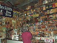
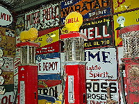 We spent part of the afternoon in John and Judy Menzies’ Birdsville Working Museum. This is another privately funded museum, with wheelwright and harnessmaker John doing a tour of the exhibits every two hours, and explaining exactly what many of them were. He also started many of the machines he had restored, and showed them actually working. Among the items we don’t recall ever seeing working before was a chain water pump, and a horse-powered chaff cutter. He also had a corrugated iron roller to produce the corrugations in galvanised sheet iron.
 We generally wandered about, finding the outlet from the hot-water bore, the ruins of another old pub, a huge service station, many telephone boxes and lots of interesting old homes. mostly still inhabited.
 The caravan park is along a waterhole in the river. Tent campers have a large area to choose from, with plenty of smallish shade trees, though if you pick a remote enough spot you’d have quite a hike to the amenities. Plenty of caravan sites, both powered and unpowered, were also available; some had a bit of shade, but most did not.
The toilet and shower blocks were huge, evidently intended for the crowds that appear for the races. At first glance the shower stalls looked good, but upon using them we discovered they were of very poor design, allowing water to splash onto the floor in the changing ares from the neighbouring stalls as well as your own. We had wondered why everyone put their shoes outside the stalls. So we wore shorts (even on a cold morning) because it was a bit far to walk in our bathrobes, and took plenty of extra over-the-door hooks to hang up everything we brought out of the reach of the water.
Birdsville to Bedourie
Thursday 9 August 2001.
At this point we realised that we didn’t have the energy to do any more serious sightseeing (and hadn’t done our homework for anywhere else), so we decided to go home. Jean thought this meant taking a week and stopping either in places we’d been before or in pleasant places with no dramatic things to see or do. Eric thought it meant driving long hours and getting home as fast as possible (at an average speed of under 80 km/hr, that still meant at least 4 days).
 On our way north from Birdsville, we stopped 14 km along the Bedourie road so we could inspect the Waddi trees, Acacia Peuce, a rare species that exists here in far Western Queensland, around Alice Springs in Central Australia, and in isolated pockets in South Africa. They looked appropriately weird and drooping (at least we assume they were the correct ones, as they had the seed pods we expected). They are said to have a very hard wood that is difficult to work, and to damage saws and axes. The aboriginals used them as digging sticks, weapons and fire sticks. European settlers used them as long lasting fence posts, some of them surviving for nearly a century.
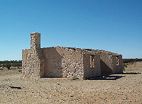 We also stopped to photograph the Cacoory homestead ruins, yet another optimistic attempt to settle in an inhospitable country. The road – called the Eyre Developmental Road – was generally in bad condition (compared to the roads in South Australia) and quite rough.
Not far from Bedourie we finally came upon patches of bitumen road, instead of the dirt roads we had been driving along for the past 1886 km. The bitumen and dirt roads alternated all the way to Bedourie (the Shire headquarters, population 120, S24.21.377 E139.28.293), but were mostly still dirt. The town was formerly called Bidouri, meaning “dust storm”, but was changed around 1895.
Our hopes of sitting in the hot artesian spa Bedourie were dashed when the local council information centre told us the pool and spa were open only when a lifeguard was on duty. They did offer to try to find us a lifeguard, if we really wanted to use the pool, but we declined to put them to the trouble.
The council had a $16.50 an hour internet connection, and would let Jean plug her own computer into the line, but as she’d just collected her mail in Birdsville, she didn’t bother to do it again. The council caravan park next to the swimming pool and Eyre Creek appeared to have good amenities, at $11, however the nearby pub had a very limited bar snack menu.
 We continued a few blocks to the Oasis roadhouse, bar, general store, and motel, where the camping facilities were absolutely wonderful for caravanners or motorhome travellers. In addition to the communal amenities, they had two little ensuite style amenity blocks, each for two camp sites. You got your own private bathroom and shower, and a sheltered area with a light in which to sit out of the wind in the evening. We were most impressed. Rates were $16 for the first night, $10 thereafter, for the ensuite facilities, less for the communal facilities. There wasn’t much shade and the camping area was really just a large dirt patch set back from the road, so tent campers would probably not find it very inviting, but for us it was great.
Lunch was sandwiches from the Oasis. They had an Internet service also, at $10 an hour, but we never found out whether Jean could plug her computer directly into their line.
We dined at the restaurant area of the Oasis. While the service was indifferent, the meal was (as usual) enormous and delicious. We had fish and chips and salad or vegetables, and Eric couldn’t finish the $13.50 meal. Great stuff. Most of the meals – other than the fish and chips – were rather more expensive than we usually find in these pubs, but they are huge, and the staff mentioned that most people take half away with them for lunch the next day, so it would be good value if you did that.
Bedourie to Boulia
Friday 10 August 2001.
We headed off for Boulia in the morning. The road was again alternating dirt and bitumen, but still mainly dirt, and seeming to get worse all the time.
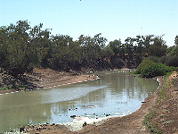 Several times we crossed Eyre Creek, where birdlife abounded. We found a sign noting the exploits of early Outback mailman Eddie “Jolly” Miller, who sometimes crossed flooded creeks with planks laid in the mud and moved in front of the wheels every two yards. With five and more creek crossings, Eddie sometimes took up to three days to get to the next town. Now the mail gets delivered by light plane to the dirt strips twice a week, and fresh food gets delivered by road train once every two weeks. Bedourie even has an electricty supply.
After 200 km we reached Boulia, a town with a population of about 400. This is the shire headquarters, with Boulia shire having a population of 600 people and an area of 60,000 square kilometres. Boulia is famous for their camel races (earlier in August), one of several outback Queensland towns that have camel races on successive weekends.
The town is also know for their MinMin experience exhibit, about a mysterious light said to follow travellers across the endless plains years ago. We didn’t bother to visit the audio-visual “experience”. We did have an excellent fish and salad lunch at the pub.
Boulia to Middleton
We kept going, now heading east on the Kennedy Developmental Road towards Winton. The road was entirely bitumen, but done as a single lane for both traffic directions. You have to dodge off the side of the road when there is oncoming traffic.
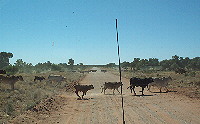 We saw some dingo pups running across the road, and some young emus, as well as many fully grown emus. Cattle and sheep started to become visible in these areas, although the vegetation here was the dry yellow I associate with the Australian countryside, rather than the green further south.
Some distance down the road we came upon the George and Gladys Hasted rest area (S22.46.349 E140.35.790), where a shelter shed and a water tank (but no toilets) were available.
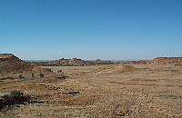
 About 170 km along the road we came across the Cawnpore lookout in the Lilyvale (Cawnporn) Hills, 52 km west of Middleton. This was a great place, on top of a hill, with a small picnic table and shelter. It gave views of a whole bunch of interesting mesa-like structures rising from what had otherwise been flat plains. The very short road up was dirt, and very steep, however we were encouraged by seeing two LandCruisers at the top. Eric put the truck into four wheel drive, and we clawed our way up the best road in second gear. The area at the top wasn’t all that large either, especially for a truck our size. However the views were fabulous. The road down was even steeper. Jean walked down to take photos, and the dust was so slippery she fell on her backside while descending. Eric took the truck down in four wheel drive and first gear.
A little further along we unexpectedly found a truck parking area off the road, with toilets and a picnic table, but no shade, and not mentioned in any of our guidebooks. S22.36.221 E141.12.891

 We finally reached Middleton, over half way between Boulia and Winton, and stopped for the night. Middleton was named after W. Middleton, one of the party with explorer John McKinlay, who entered this area in April 1862. Middleton (population about 6) consists of a very small pub and a somewhat broken looking community hall. Camping was free in an open area across the road from the pub, and showers were available for $2 each donation to the Royal Flying Doctor (but first someone has to get the wood and light the chip heater).
The camping area had a sign saying “Hilton Hotel – no airconditioning, no rooms, no laundry, no charge”. The pub did appear to have a few motel-type units, old portable huts. We had steak sandwiches from the pub for dinner.
Middleton to Hughenden via Winton
Saturday 11 August 2001.
We headed for Winton in the morning, arriving a little after 11. This was the first large town (population about 1200?) we had been in for weeks, so we checked for a money machine (couldn’t find one), and a newsagent (Saturday papers don’t arrive until Sunday). Jean’s CDMA phone started working well before Winton, however my GSM didn’t. We’d been here on our trip last year, so we’d seen some of the sights and didn’t plan to linger this time.
We shared a damper roll at the Matilda Centre since their food was good last time, but are still not inclined to view their high tech exhibit. The North Gregory pub now had an internet connection for about $3 an hour, and there was another such connection listed in town. We did get some fuel, to make sure we wouldn’t run out before we got back to someplace where it was cheaper. We took on 166 litres in the now empty rear tank, at a price finally just under $1 a litre. Our previous refueling stop had been Marree, 1308 km ago.
At Corfield (population 10) we had hoped to stop at the pub, but today was their race day, and everyone in town was at the race track.
We continued on the Kennedy Developmental Road towards Hughenden. We finally got hungry again and stopped at a little roadhouse at Stamford (population 5) for meat pies and a drink. We didn’t reach Hughenden (population 1500) until after 4 pm, and couldn’t see any reason to stay. Jean’s CDMA phone worked, but not my GSM.
Hughenden to Townsville with a stop in Torrens Creek
Eric wanted to press on, so we continued on a fairly horrible road out of Hughenden towards Charters Towers. The road – the main Route 1 Flinders Highway from Townsville to Mount Isa and the Northern Territory – had obviously been a badly rutted single lane a few years ago. Whoever “upgraded” it just put bitumen over it, and over the verges. All the old patches were retained, so the road surface is everywhere irregular, and too narrow for two large trucks. The new bitumen had cracked in many places, and the dirt sides were badly rutted. Eric thought it by far the most dangerous road we had been on in during the trip.
 We passed through Prairie, population 46, without stopping. About 90 km east of Hughenden we stopped at Torrens Creek (S20.546.190 E145.01.167, population 16). The pub, general store and tourist office there had a small caravan park alongside. The small town alongside the railway line even had electricity they didn’t generate themselves. It also boasts the smallest golf club in Australia, with a total of five members. Naturally our phones didn’t work.
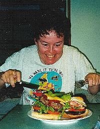
While in the pub, Eric saw a Yowie Burger served to one of the people. He asked Jean if she would like to share one of these $8.80 burgers. It was too large for the both of us! We have a photo to prove it! Highly recommended. We collapsed early, having covered 484 km today, probably our longest distance during the trip.
Townsville and home
Sunday 12 August 2001.
We departed Torrens Creek well before nine, and continued along a fairly rough and narrow bitumen road. There was a very attractive lookout point at White Mountain National Park, about 23 km east of Torrens Creek, and we also came across a nice rest stop 70 km along, near a river and with shelter and toilets. S20.26.479 E145.31.989
We were intending to park somewhere in Charters Towers and find a newsagent in the business area, however the bypass took us straight out of town so we just ignored the city entirely. The place was too large for us anyway, with 10,000 people. We’d stopped there last year, coming from the north. Some trip we’ll take the time to see some of the historic buildings and other attractions of the town.
There was a badly signposted rest area a kilometre off the road near the river some 32 km past Charters Towers. Lots of people staying there. Reid River 82 km past Charters Towers also had a large rest area with toilets and shelters. S19.45.413 E146.50.001
There was a large Mobil service station 88 km from Charters Towers, most of the way to Townsville in fact, with a clear access to the diesel pumps; good prices too. They had toilets and showers available 24 hours. We took advantage of the space at the pumps to totally refill the front tank, taking 325 litres. This gave us an indicated range of 1863 km using both tanks.
We reached Townsville after 1 pm, and made our way through the quiet Sunday traffic to the caravan park near the Sizzlers restaurant. Disaster. The caravan park has a load limit of 4 tonnes on their roads, and their spaces were designed for a vehicle of 25 feet or less. We couldn’t stay there. We also discovered they were nearly full, possibly because of the Federation celebrations in Townsville the day before.
After some manouvering, we managed to park at the Sizzlers car park (one wheel up on a curb, in a corner of the car park so we wouldn’t block cars). So we at least had our late lunch at Sizzlers.
We considered trying one of the other caravan parks, however none of them were convenient to any of the places at which we wanted to shop. The truck is too large to contemplate getting into most of the shopping areas, so we want to park within walking distance. If we had arrived on Monday, we could have parked somewhere for the afternoon and done some shopping, but nothing was open on Sunday. So we decided to keep heading for home, even though it was now too late for us to get home that same day.
We went through Ayr and tried the Inkerman caravan park. It was full due to the fruitpicking season. We were now back in countryside where you can’t just camp beside the road, because the road is mostly lined with canefields, and the rest areas are few and frequently posted for no camping allowed.
We ended up at Gumlu, where we could squeeze into this non-tourist park. It appeared to be full of itinerant fruit-pickers, who fortunately turned off their radios and went to sleep early, rising at dawn to go to work. The amenities were poorly maintained.
Monday 13 August 2001.
We left Gumlu early and reached Airlie Beach well before lunch. Another successful and very enjoyable, if exhausting, trip.
For more information about places mentioned
Two good sites for more information about the places mentioned in this newsletter are Travelmate and Walkabout.