
Karratha to Exmouth and Cape Range NP (8 days)
These notes were written by Eric and occasionally amended by Jean. Eric took some of the photos and Jean took others. All photos were selected, cropped, and inserted into this file by Jean. Factual information was taken from various sources including tourist brochures; we do not guarantee its accuracy.
Click on a photo to see a full size version. Not recommended for readers on dialup connections — some of these files are between 1 and 2 MB.
Photo albums from this part of the trip (more photos than shown on this page) are here: Days 40-45, Days 46-48.
Day 41, Dampier, Thursday 15 July 2004
The weather had again turned cloudy, and we had light rain for much of the day. Given the average rainfall at Dampier, Karratha, and Exmouth is under 240mm a year, we have to ask why now?
We left the Karratha motel as late as we could and visited Back Beach, with its boat ramp and view to sea. We also drove around the town, getting an idea of what was there. Mostly residences for workers, plus infrastructure. The centre seemed to be one of the largest towns we had encountered for a fair while. It even had a cinema, and a shopping mall.
When we reached Dampier (pop 2000, latitude S20.40, longitude E116.42, map ref. 29), we drove around the town and found a lookout which gave a good view of the harbour area. It seemed a fairly typical industrial town of a few decades ago. Pretty much all the essentials were there.
We were able to get our room at the Mermaid Hotel Motel a little earlier than the nominal 2 p.m. check in time. Jean was still feeling poorly, and rested for most of the day. Despite occasional rain, Eric managed to get the laundry done. A small cafe across the shopping centre parking lot supplied a lunch.
On a mission to find us a bottle of wine to go with dinner, Eric found a bottle of Brown Bros Very Old Port at a very good price. Just the thing to help cheer Jean up, and treat her cold.
With most shops closed by dinner time, we got a bar snack at the motel pub and took it back to the room. The bar was way too smoke filled and noisy for us to want to remain there. They had seven TV screens, all apparently showing different sports events, and a jukebox playing rusty music.
It rained all night. As far as we can tell from the TV weather report, it is only raining where we are, following us down the coast.
Day 42, Karratha, Friday 16 July 2004
After driving around as much of the town of Dampier as we could, we drove further up the peninsula. It was an overcast day, with some rain, so visibility wasn’t good from the few lookout points we visited. We tried to find the Dampier visitors centre, and the Dampier salt lookout, both marked on the artistic but not all that accurate map, but could locate neither.
 We checked out the very nice visitors’ centre for the North West Shelf project, where there is a massive LPG gas plant. The offshore gas and oil rigs have been producing since at least the 1980s, with gas being shipped to Japan by tanker, and to Perth and elsewhere via the extensive gas pipelines that run from many fields in Australia. There have been recent reports of further useful although not major oil and gas finds in the area.
 We noticed a remarkable number of Sturt Desert Peas in flower on the peninsula, especially along the gravel edges of the roads to the LPG plant. We haven’t seen them blooming like that before at any place we’ve visited. The rain has brought out an impressive number of wildflowers.
Then it was back the short distance to Karratha. We wasted some time in the shopping centre, since we needed lunch anyway, while we waited for a likely time for our room to be available.
Once at the motel, we tried making a room booking for several nights for our next stopping place, at Exmouth. This wasn’t one of the options at all. It seems school holidays extend a week longer than we thought, and the place is booked out. Jean eventually managed to find a room for one night over the internet. We hope we’ll be able to find someplace for another few nights, so we have a chance to visit the National Park near Exmouth—assuming the weather cooperates, that is.
Day 43, Karratha, Saturday 17 July 2004
We are having a rest day. I hope this helps us both recover from our colds, especially before we get out of the tropics and hit cold climates. Between the weather and our colds, we’ve decided not to make the long drive into Millstream Chichester National Park. Unless we camp, there is no place to stay anywhere near the park, so we’d have to drive in and back the same day (on a gravel road), leaving little time to actually appreciate the place.
We still have cloudy weather, mostly just where we are, but now extending to where we will be in a few days.
Day 44, Karratha, Sunday 18 July 2004
 Sunshine and great weather finally returned, after seemingly endless cloud.
We drove off and visited the historic buildings in Roebourne, where the old jail has been turned into an art display and visitors centre area.
 We also found the road to the hill lookout where the town water tank and TV repeater stands. This gave us a fine view over the town and nearby countryside.
Back at Karratha, we also found the hill lookout next to the visitors’ centre. This gave us views of Karratha, including a direct view of the hotel at which we are staying, just behind the shopping mall and Coles store. Wildflowers were plentiful around the lookout.
In the evening, Jean made a lot of phone calls and finally managed to book motel rooms for the next week.
Day 45, Karratha to Exmouth, Monday 19 July 2004
We set out early for a long day of driving. About 130 km down the road we came upon the Fortescue River roadhouse. No sign of life there, except for more wedgetail eagles, but the toilets worked.
 Along the way it was very obvious that flooding had been bad this year (possibly caused by the cyclones that came through the area). We came across a bypass around a high level bridge. Although the concrete support columns and steel bridge structure had survived a flood that was higher than the bridge, the flood waters had washed away the road on each side, leaving the ends of the bridge standing many feet in the air.
 Somewhat later we saw a concrete culvert bridge that had simply mostly washed away entirely. Both were being repaired.
About 270 kilometres down the road we reached Nanutarra roadhouse, where we bought a lunch for later. The bridge beside Nanutarra roadhouse, across the Ashburton River, was single lane. A second bridge was being constructed alongside the original one.
 We finally stopped for lunch at a rest area near the Yannarie River. Lots of caravan people had the same idea.
About 40 kilometres past the rest area was a minor road leading off from the North West Coastal Highway. This took us about 75 kilometres west to the coastal road leading to Exmouth. Actually this was only the second road to the coast (the other being to Onslow) in the entire distance we drove.
The cape and hinterland appears very sandy. It is basically desert, with less than a foot of rainfall a year, despite sticking out into the Indian Ocean, and being (just) within the tropics.
We stopped at the Exmouth Visitor Centre to collect what maps and tourist details we could. Exmouth (population 2400, latitude S, longitude E, map ref. 30) was established in 1967 as a support town for the joint USA Australia naval communications station on North West Cape. The town was in the path of tropical cyclone Vance on 22 March 1999, and nearby Learmonth RAAF base recorded the highest ever wind gusts on the Australian mainland.
The area was named North West Cape by an Australian, Captain Phillip Parker King, who visited in 1818. He also named Exmouth Gulf after a Royal Navy officer. However the first known European visitor was in 1618, when Dutch Captain Jacobz brought the Mauritius into the area.
Despite having had beautiful sunshine during almost the entire drive, the skies were now overcast. One of the things the Visitor Centre brags about is that Exmouth has the perfect weather, no wet season. When we returned to Exmouth to collect some dinner supplies (like a bottle of wine) we got lightly rained upon. The weather report that evening showed that it was expected to rain exactly where we were, and where we wished to visit. Just great!
We had booked into the Best Western Sea Breeze resort, located 5 km north of Exmouth, for Monday. This motel was formerly inside the original 1967 Harold E Holt naval communications military base, and was converted from one of the former bachelor officer’s or enlisted men’s quarters.
 The motel is certainly interesting. Most of the rooms are set up as four rooms opening onto a common area, with access to the common rooms from an outside balcony. We noted that some common areas had cooking facilities.
The rooms are very large, and the bed was comfortable. There was a nice desk, but no chairs. The sort of piano stool really didn’t work well with our elderly backs, so e borrowed the only chair from the furniture in our common room. The Internet access point and several power points were conveniently located by the desk. Unfortunately, the Internet line could only manage a pathetic 19,200 kbps.
This motel will be a contender to win our annual award for the worst lit room we have encountered. They have tried to do the right thing, with (weak) reading lamps on each side of the bed, and a (small) desk lamp. However the only main light in this giant room was a small fluorescent high on one wall. The overall effect is, perhaps, romantic, but not very practical.
The upstairs rooms had cyclone grilles across the windows, and a collection of grilles was downstairs, ready to be put in place quickly if required. Given the nearby Learmonth RAAF base recorded the Australian record wind gusts (267 kph) during a cyclone, this preparedness isn’t surprising.
Despite our complaints, overall the Sea Breeze worked fine for our purposes, and we were very pleased to have had a chance to see what had been done with the naval base building.
Day 46, Exmouth, Tuesday 20 July 2004
 We headed north around the cape, towards the seaward side of the peninsula. Just about all the coastal areas are nature parks or National Park. We saw typical roadside signs like don’t feed the emu. Much of the other land is devoted to antenna farms for the naval communication facility. We saw several clusters of antennas, some of them exceedingly large.
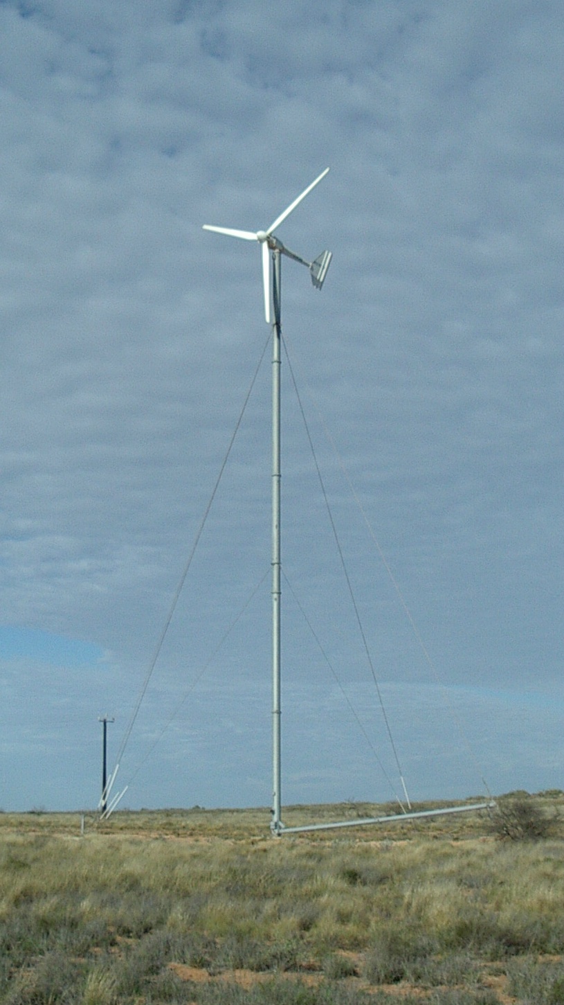 Jean says this place blows you away, and indeed, it was so very windy that we soon encountered a small experimental windfarm! This was very small, with three turbines, each with 10 metre diameter blades on a 30 metre pole, generating 20 kW per turbine. Still, Western Power claim the June 2002 construction saves 50,000 litres of diesel a year. The towers used are capable of being lowered prior to cyclones, obviously an important consideration in the northwest.
The road was mostly out of sight of the sea, as it was on the landward side of the large vegetated sand dunes that protect the coast. We drove past the large Lighthouse caravan park, which seemed to contain nearly as many boats as caravans, close to the sea but protected somewhat from the strong wind by the line of sand dunes on the seaward side of the road.
 Vlaming Head lighthouse was on a prominent hill, and thanks to federal funding, there was an easy road up the steep incline. We were astonished to note some older runners coming down the hill. At least they had the grace to look tired.
The Vlaming Head lighthouse is the only restored kerosene fired lighthouse in Australia. It is also the site of a WWII aircraft warning radar installation destroyed in February 1945 by a cyclone. The remains are there next to the lighthouse. Shipping in Exmouth Gulf was bombed by Japanese aircraft in May 1943.
You get excellent views of the coastline from here. You can also just see some of the largest antenna masts faint in the distance, over the top of the caravan park spread out on the flat land below the hill. The caravan park’s expensive chalets were on a hill from which they probably had sea views. It seemed a nice spot.
Jurabi coastal reserve includes turtle rookeries, where you can view turtles during the summer months. A new turtle information centre by the beach was established in February 2004. This gives a description of turtle behaviour, and how humans can avoid disrupting the turtles.
 As we walked back along the path to the car, a curious emu turned up to watch us go.
Do we need to mention that the further we went, the more clouds we encountered? The later in the day, the more dense the cloud, and more threatening it appeared. It was probably only the clouds that protected us from sunburn, as the wind was so fierce we couldn’t possibly wear our hats.
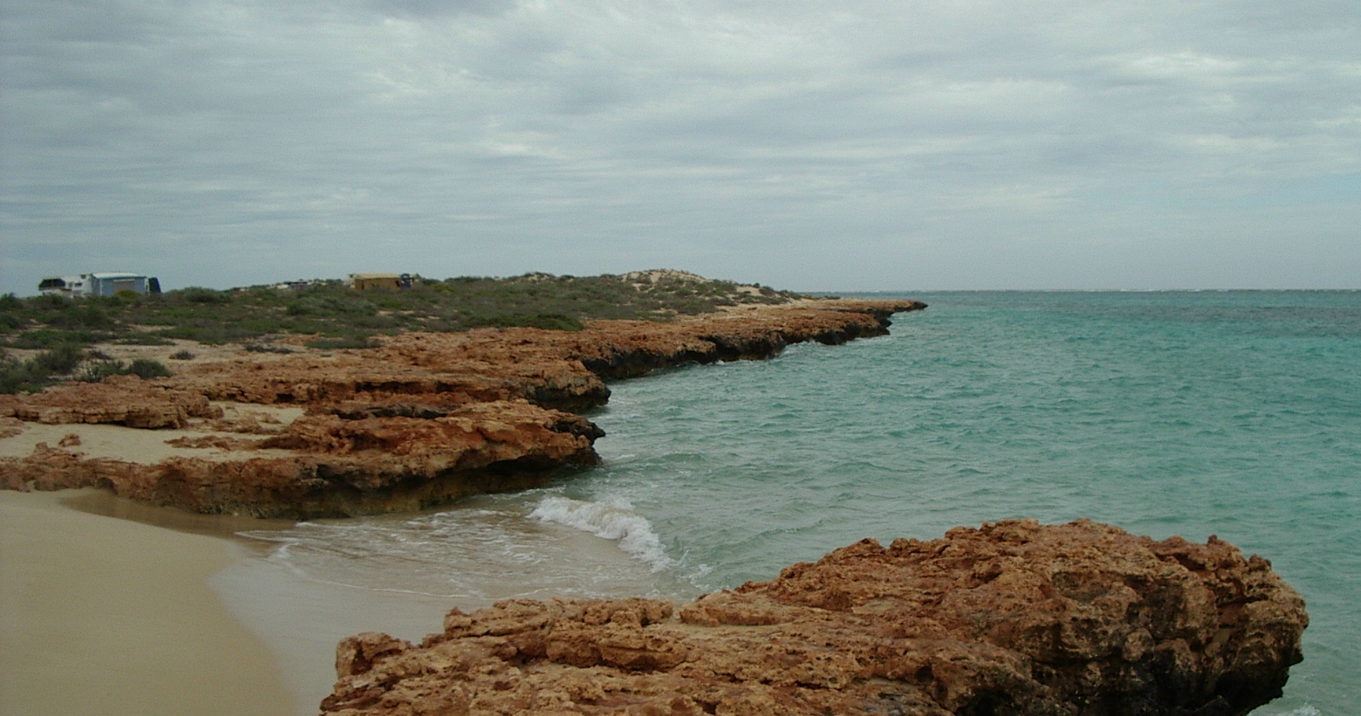
We soon entered the Cape Range National Park, which is the only elevated limestone range on the northwest coast of West Australia. It occupies 50,581 hectares of mostly former pastoral lease land. There are views of Ningaloo Reef from many spots along the road and beaches.
We decided to continue as far as we could, because of the increasing cloud cover, in the hope we could visit closer areas on subsequent days. It was on this made road, with gravel edges, that we got yet another couple of stone chips on the windscreen when rocks were thrown up by passing vehicles.
 Yardie Creek and gorge is where the good road ends, and you need a 4WD to cross the sandy bottom of the creek at low tide. There are warning signs about the consequences of getting bogged on a rising tide. There is a short, easy walk here, which then leads to a longer difficult walk.
Yardie Creek boat tours have a one hour trip up the gorge at 10:30 and 12:30, wind and weather conditions permitting. Seems a good way to see an otherwise difficult area. Operators claim that you sometime see rare black footed rock wallabies (Petrogale lateralis). As the gorge is open to seawater at high tide, the water is actually salty.
 With the weather still cloudy, and very windy, we started driving back, stopping at some of the many beach access area where dirt roads took you the short way to the beach or to over 90 camping and caravan sites.
We checked the Osprey Bay camping and caravan area, which as usual in National Parks had only pit or bio toilets as facilities, and nothing else. If you are self contained, including water and cooking facilities (no burning wood), it would be a nice place to stay.
We sighted either an osprey or a sea eagle sailing high in the sky. Looked very like the one we see at home, and was equally hard to photograph.
We noted the Ningaloo Reef Retreat track, where you could pay A$155 a night to sleep in a swag under the stars, and help prepare your own meals from their cookbook (they do however supply the fresh food).
 Bloodwood Creek offered some views of the dry creek, and various beach areas. There were large flocks of corellas on the sand, and these burst into view when disturbed by fishermen.
At South Mandu there was no camping, but there was a walking track of 500 metres to a beach. North Mandu, on the other side of the dry river delta, did have a camping area close to the beach.
 Mandu Mandu gorge had a walking track. The track along the top of the north ridge of the gorge is rocky, full of potholes to snare the foot, and has two steep gullys near the start of the walk. It eventually descends into the gorge, so you return along the gorge floor after several hours. We did get some photos, but in fairly indifferent light.
Milyering visitor centre, 52 kilometre from Exmouth, is an environmentally friendly rammed earth structure with some solar power and wind pump for water (which is in short supply). It has the usual visitor centre and National Park material, plus a tourist shop with books and souvenirs, plus soft drinks and ice cream.
Ningaloo Reef extends some 260 kilometres from the cape down past Coral Bay. The fringing reef seen offshore protects a shallow lagoon-like area that is two to four metres deep. In some places the fringing reef almost reaches the shore, allowing easy access from the coast. Viewing distances are reduced because it is close to the coast, however it has many species.
Many of the snorkelling areas are entered via beaches that have numerous rocky areas.
From Tuesday to Thursday we are staying in a duplex chalet room at the Ningaloo Caravan and Holiday Resort, opposite the visitors centre, near the heart of Exmouth. It has kitchen facilities, ensuite, a fancy TV with a DVD player, an a gas barbecue on the porch. Everything looks quite new.
After checking in, we went shopping for dinner items. On our walk we noted that Blue’s Internet Cafe had both phone and ethernet access for laptop users, albeit at a slight premium on the usual price.
Day 47, Exmouth, Wednesday 21 July 2004
We woke late to the sound of rain on the roof. Every time we thought to take a walk or do any sort of tourist thing the wind picked up pace, and it rained some more. We did go out a couple of times, just routine stuff like shopping for dinner ingredients, but mostly spent the day typing.
The room has a full kitchen with a gas stove, so Jean decided she would cook a dinner, for the first time since Mataranka.
We took a later walk, intending to seek out Town beach. Got rained on lightly, and soon returned via way of an even cheaper internet cafe, and a second hand bookshop.
Day 48, Exmouth, Thursday 22 July 2004
The weather began badly, alternating sunshine with showers too quickly to take much advantage of the sunshine, but improved after lunch.>/p>
In the afternoon we were able to visit the eastern edge of the Cape Range National Park, by heading south along the main road out of Exmouth, where there is easy access to some nice gorges in the ranges.
 Shothole Canyon Road is a 13 kilometre dirt road into the park, with very decent cliff and gulf views from many points along the road. We had cloud cover, and little sun for photographs, but very little rain. There were some puddles on the road, but it wasn’t enough to cause problems. The walking track to the next gorge was closed. In looking at the state of the cliffs and the fragile nature of the ground, we don’t think we’d have wished to attempt them in any case.
 Charles Knife Road starts as bitumen, and only becomes a dirt road after it has climbed most of the eastern escarpment. Apart from some spectacular views along the road, and some great lookouts, it also leads to the site of a very early (failed) oil drilling site at the far end of the road. If you only take one road into the gorges, this should probably be it.
We went to the nearest pub to collect steak sandwiches for dinner. A band was doing sound tests as they set up their equipment, so we were very pleased to escape as soon as possible.
We somehow managed to miss the TV weather report this evening, although with the rain being audible we very much wanted to check conditions for the following day.
Page last updated 2 January 2005